
Tokyo topographic map
Interactive map
Click on the map to display elevation.
About this map
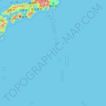
Name: Tokyo topographic map, elevation, terrain.
Location: Tokyo, Japan (20.21458 135.85369 35.89842 154.20554)
Average elevation: 22 m
Minimum elevation: -3 m
Maximum elevation: 3,459 m
The mainland portion of Tokyo lies northwest of Tokyo Bay and measures about 90 km (56 mi) east to west and 25 km (16 mi) north to south. The average elevation in Tokyo is 40 m (131 ft). Chiba Prefecture borders it to the east, Yamanashi to the west, Kanagawa to the south, and Saitama to the north. Mainland Tokyo is further subdivided into the special wards (occupying the eastern half) and the Tama area (多摩地域) stretching westwards. Tokyo has a latitude of 35.65 (near the 36th parallel north), which makes it more southern than Rome (41.90), Madrid (40.41), New York City (40.71) and Beijing (39.91).
Other topographic maps
Click on a map to view its topography, its elevation and its terrain.
Motegi
Motegi, Haga County, Tochigi Prefecture, 321-3531, Japan
Average elevation: 145 m
Yamanouchi
Yamanouchi, Shimotakai County, Nagano Prefecture, Chubu Region, Japan
Average elevation: 942 m
Ogawara
Ogawara, Shibata County, Miyagi Prefecture, Japan
Average elevation: 40 m
Kami
Japan > Mikata County > Kami
Kami, Mikata County, Hyogo Prefecture, Japan
Average elevation: 172 m
Okinoshima
Japan > Oki County > Okinoshima
Okinoshima, Oki County, Shimane Prefecture, 6858585, Japan
Average elevation: 10 m
Nakanojo
Japan > Agatsuma County > Nakanojo
Nakanojo, Agatsuma County, Gunma Prefecture, Japan
Average elevation: 882 m
Osaka
Japan > Kinki Region > Osaka
Kita, Osaka, Osaka Prefecture, Kinki Region, Japan
Average elevation: 10 m
Miyashitadori
Japan > Asahikawa > Miyashitadori
Miyashitadori, Asahikawa, Kamikawa Subprefecture, Hokkaido Prefecture, 070-0030, Japan
Average elevation: 118 m