
Mourne Mountains West topographic map
Interactive map
Click on the map to display elevation.
About this map
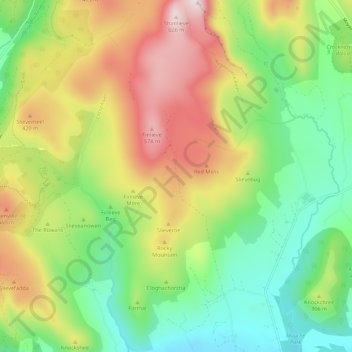
Name: Mourne Mountains West topographic map, elevation, terrain.
Average elevation: 272 m
Minimum elevation: 30 m
Maximum elevation: 633 m
Other topographic maps
Click on a map to view its topography, its elevation and its terrain.
Newry
United Kingdom > Northern Ireland > Newry
Newry, County Down, Northern Ireland, United Kingdom
Average elevation: 73 m
Lisdrumgullion
United Kingdom > Northern Ireland > Newry
Lisdrumgullion, Newry, County Down, Northern Ireland, BT35 6BH, United Kingdom
Average elevation: 41 m