
Vladivostok topographic map
Interactive map
Click on the map to display elevation.
About this map
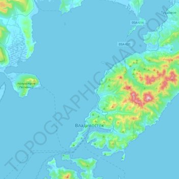
Name: Vladivostok topographic map, elevation, terrain.
Average elevation: 29 m
Minimum elevation: -3 m
Maximum elevation: 453 m
Vladivostok has a monsoon-influenced humid continental climate (Köppen climate classification Dwb) with warm, humid and rainy summers and cold, dry winters. Owing to the influence of the Siberian High, winters are far colder than a latitude of 43 degrees north should warrant given its low elevation and coastal location, with a January average of −12.3 °C (9.9 °F). Since the maritime influence is strong in summer, Vladivostok has a relatively cold annual climate for its latitude. Vladivostok's yearly mean of around 5 °C (41 °F) is some ten degrees lower than in cities on the French Riviera on a similar coastal latitude in Europe on the other extreme. Winters especially are around 20 °C (36 °F) colder than on the mildest coastlines this far north, and are considerably colder than locations on the North America east coast at similar latitudes such as Halifax, Nova Scotia and Portland, Maine.