
Copeland topographic map
Interactive map
Click on the map to display elevation.
About this map
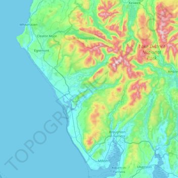
Name: Copeland topographic map, elevation, terrain.
Location: Copeland, Cumbria, North West England, England, United Kingdom (54.16784 -3.64062 54.60734 -3.11414)
Average elevation: 156 m
Minimum elevation: 0 m
Maximum elevation: 962 m
Other topographic maps
Click on a map to view its topography, its elevation and its terrain.
Millom
United Kingdom > England > Copeland > Millom
Millom, Copeland, Cumbria, North West England, England, LA18 5BD, United Kingdom
Average elevation: 25 m
Scafell Pike
United Kingdom > England > Copeland
Scafell Pike, Copeland, Cumbria, North West England, England, CA20 1EX, United Kingdom
Average elevation: 679 m