
Mount Cook Village topographic map
Interactive map
Click on the map to display elevation.
About this map
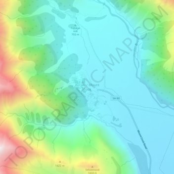
Name: Mount Cook Village topographic map, elevation, terrain.
Average elevation: 984 m
Minimum elevation: 673 m
Maximum elevation: 1,930 m
Other topographic maps
Click on a map to view its topography, its elevation and its terrain.
Red Tarns
New Zealand > Canterbury > Mount Cook Village
Red Tarns, Red Tarns Track, Mount Cook Village, Mackenzie District, Canterbury, 7946, New Zealand
Average elevation: 997 m
Eugenie Glacier
New Zealand > Canterbury > Mount Cook Village
Eugenie Glacier, Hooker Valley Track, Mount Cook Village, Mackenzie District, Canterbury, 7946, New Zealand
Average elevation: 1,827 m
Mueller Glacier
New Zealand > Canterbury > Mount Cook Village
Mueller Glacier, Mueller Hut Route, Mount Cook Village, Mackenzie District, Canterbury, 7946, New Zealand
Average elevation: 1,616 m