
North District topographic map
Interactive map
Click on the map to display elevation.
About this map
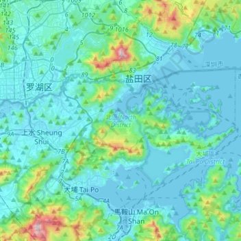
Name: North District topographic map, elevation, terrain.
Location: North District, New Territories, Hong Kong, China (22.46562 114.07835 22.56833 114.33618)
Average elevation: 115 m
Minimum elevation: -4 m
Maximum elevation: 946 m
Other topographic maps
Click on a map to view its topography, its elevation and its terrain.
19
China > Hong Kong > Hong Kong Island
19, Government Hill, Central, Central and Western District, Hong Kong Island, Hong Kong, China, Hong Kong Park
Average elevation: 143 m
Lamma Island
Lamma Island, Islands District, New Territories, Hong Kong, China
Average elevation: 20 m
Hong Kong Island
China > Hong Kong > Hong Kong Island
Hong Kong Island, Southern District, Hong Kong, 852, China
Average elevation: 36 m
Kowloon City District
Kowloon City District, Kowloon, Hong Kong, 000000, China
Average elevation: 37 m
Eastern District
China > Hong Kong > Hong Kong Island
Eastern District, Hong Kong Island, Hong Kong, China
Average elevation: 84 m