
Evanston topographic map
Interactive map
Click on the map to display elevation.
About this map
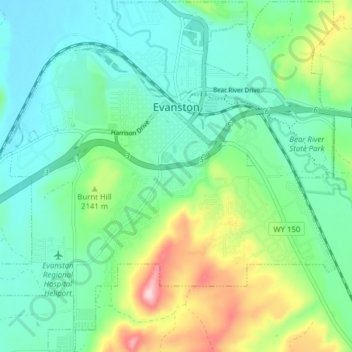
Name: Evanston topographic map, elevation, terrain.
Location: Evanston, Uinta County, Wyoming, United States of America (41.22750 -111.00557 41.28601 -110.92856)
Average elevation: 2,100 m
Minimum elevation: 2,033 m
Maximum elevation: 2,285 m
Evanston is located at 41°15′48″N 110°57′53″W / 41.26333°N 110.96472°W / 41.26333; -110.96472 (41.263302, −110.964616). The elevation is 6749 feet (2057 m) above sea level.