
Asturias topographic map
Interactive map
Click on the map to display elevation.
About this map
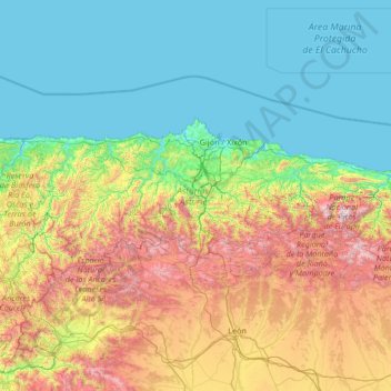
Name: Asturias topographic map, elevation, terrain.
Location: Asturias, Spain (42.88254 -7.18317 43.66451 -4.51059)
Average elevation: 569 m
Minimum elevation: -2 m
Maximum elevation: 2,593 m
Other topographic maps
Click on a map to view its topography, its elevation and its terrain.
Río Carrocedo
Spain > Asturias > Llanes > Parres
Río Carrocedo, Parres, Llanes, Asturias, 33500, Spain
Average elevation: 34 m
Grandas de Salime
Spain > Asturias > Grandas de Salime
Grandas de Salime, Asturias, Spain
Average elevation: 653 m
Cantabrian Mountains
Cantabrian Mountains, Cabrales, Asturias, Spain
Average elevation: 2,211 m