
Central Sulawesi topographic map
Interactive map
Click on the map to display elevation.
About this map
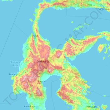
Name: Central Sulawesi topographic map, elevation, terrain.
Location: Central Sulawesi, Indonesia (-4.25378 118.24886 0.86622 123.36886)
Average elevation: 256 m
Minimum elevation: -2 m
Maximum elevation: 3,227 m
Other topographic maps
Click on a map to view its topography, its elevation and its terrain.
Palu
Palu, Kecamatan Palu Timur, Palu, Central Sulawesi, 94222, Indonesia
Average elevation: 531 m
Lore Lindu National Park
Indonesia > Central Sulawesi > Dodolo
Lore Lindu National Park, Dodolo, Poso Regency, Central Sulawesi, Indonesia
Average elevation: 1,124 m
Parigi Moutong Regency
Parigi Moutong Regency, Central Sulawesi, 94471, Indonesia
Average elevation: 133 m
Peleng Island
Peleng Island, Banggai Islands Regency, Central Sulawesi, Indonesia
Average elevation: 117 m