
Gunma Prefecture topographic map
Interactive map
Click on the map to display elevation.
About this map
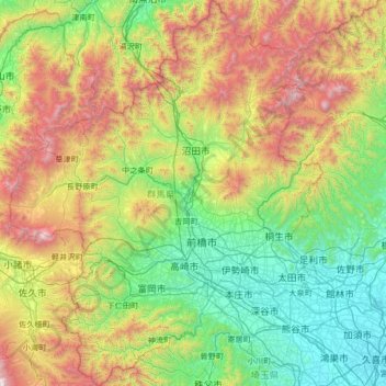
Name: Gunma Prefecture topographic map, elevation, terrain.
Location: Gunma Prefecture, Japan (35.98533 138.39702 37.05863 139.66994)
Average elevation: 768 m
Minimum elevation: 6 m
Maximum elevation: 2,748 m
Other topographic maps
Click on a map to view its topography, its elevation and its terrain.
Kanra District
Nanmoku, Kanra District, Gunma Prefecture, Kanto, Japan
Average elevation: 791 m
Tone River
Japan > Gunma Prefecture > Itakura
Tone River, Itakura, Ora District, Gunma Prefecture, Kanto, 3770201, Japan
Average elevation: 447 m