
Eugene topographic map
Interactive map
Click on the map to display elevation.
About this map
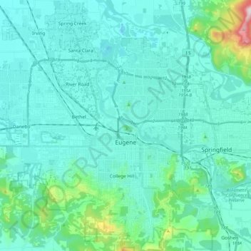
Name: Eugene topographic map, elevation, terrain.
Location: Eugene, Lane County, Oregon, United States (43.98753 -123.20876 44.13227 -123.03589)
Average elevation: 163 m
Minimum elevation: 88 m
Maximum elevation: 689 m
According to the United States Census Bureau, the city has a total area of 43.74 square miles (113.29 km2), of which 43.72 square miles (113.23 km2) is land and 0.02 square miles (0.05 km2) is water.[47] Eugene is at an elevation of 426 feet (130 m).
Other topographic maps
Click on a map to view its topography, its elevation and its terrain.
Lane County
United States > Oregon > Lane County
Lane County, Oregon, United States
Average elevation: 712 m