
Bengaluru topographic map
Interactive map
Click on the map to display elevation.
About this map
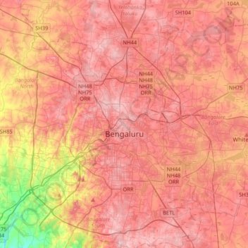
Name: Bengaluru topographic map, elevation, terrain.
Location: Bengaluru, Bangalore North, Bangalore Urban, Karnataka, India (12.83401 77.46010 13.14366 77.78405)
Average elevation: 881 m
Minimum elevation: 722 m
Maximum elevation: 965 m
Bangalore (/ˈbæŋɡəlɔːr, ˌbæŋɡəˈlɔːr/ BANG-gə-lor, -LOR), officially Bengaluru (Kannada pronunciation: [ˈbeŋgɐɭuːɾu] ), is the capital and largest city of the southern Indian state of Karnataka. It has a population of more than 8 million and a metropolitan population of around 15 million, making it India's third most populous city and fourth most populous urban agglomeration. It is the most populous city and largest urban agglomeration in South India, and is the 27th largest city in the world. Located on the Deccan Plateau, at a height of over 900 m (3,000 ft) above sea level, Bangalore has a pleasant climate throughout the year, with its parks and green spaces earning it the reputation of India's "Garden City". Its elevation is the highest of India's major cities.