
Thank you for supporting this site ❤️
Make a donation
Make a donation
Gisborne topographic map
Click on the map to display elevation.
Thank you for supporting this site ❤️
Make a donation
Make a donation
About this map
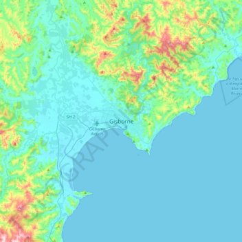
Name: Gisborne topographic map, elevation, terrain.
Location: Gisborne, Gisborne District, Gisborne, 4010, New Zealand (-38.82133 177.86065 -38.50133 178.18065)
Average elevation: 70 m
Minimum elevation: 0 m
Maximum elevation: 507 m
Gisborne District trails, hiking, mountain biking, running and outdoor activities
Thank you for supporting this site ❤️
Make a donation
Make a donation