
Make a donation
Christchurch topographic map
Click on the map to display elevation.
Make a donation
About this map
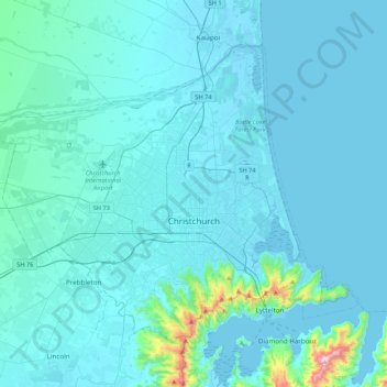
Name: Christchurch topographic map, elevation, terrain.
Location: Christchurch, Christchurch City, Canterbury, New Zealand (-43.62859 172.42398 -43.43462 172.77977)
Average elevation: 46 m
Minimum elevation: -3 m
Maximum elevation: 700 m
Christchurch City trails, hiking, mountain biking, running and outdoor activities
Make a donation
Other topographic maps
Click on a map to view its topography, its elevation and its terrain.
Akaroa
New Zealand > Canterbury > Christchurch City > Banks Peninsula Community
Average elevation: 108 m
Takamatua
New Zealand > Canterbury > Christchurch City > Banks Peninsula Community
Average elevation: 101 m
Un named plug
New Zealand > Canterbury > Christchurch City > Banks Peninsula Community > Diamond Harbour
Average elevation: 164 m
Barrys Bay
New Zealand > Canterbury > Christchurch City > Banks Peninsula Community
Average elevation: 100 m
Make a donation
Haytor
New Zealand > Canterbury > Christchurch City > Banks Peninsula Community
Average elevation: 348 m
Brasenose
New Zealand > Canterbury > Christchurch City > Banks Peninsula Community
Average elevation: 483 m
New Brighton Beach
New Zealand > Canterbury > Christchurch City > Coastal-Burwood Community
Average elevation: 4 m
Styx Mill Conservation Reserve
New Zealand > Canterbury > Christchurch City > Christchurch
Average elevation: 14 m
Make a donation