
Make a donation
Wellington topographic map
Click on the map to display elevation.
Make a donation
Wellington
Averaging 2,055 hours of sunshine per year, the climate of Wellington is temperate marine, (Köppen: Cfb), generally moderate all year round with warm summers and mild winters, and rarely sees temperatures above 23 °C (73 °F) or below 4 °C (39 °F). The hottest recorded temperature in the city is 31.1 °C (88 °F), while −1.9 °C (29 °F) is the coldest. The city is notorious for its southerly blasts in winter, which may make the temperature feel much colder. It is generally very windy all year round with high rainfall; average annual rainfall is 1,250 mm (49 in), June and July being the wettest months. Frosts are quite common in the hill suburbs and the Hutt Valley between May and September. Snow is very rare at low altitudes, although snow fell on the city and many other parts of the Wellington region during separate events on 25 July 2011 and 15 August 2011. Snow at higher altitudes is more common, with light flurries recorded in higher suburbs every few years.
Make a donation
About this map
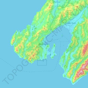
Name: Wellington topographic map, elevation, terrain.
Location: Wellington, Wellington City, Wellington, 6011, New Zealand (-41.44880 174.61721 -41.12880 174.93721)
Average elevation: 85 m
Minimum elevation: -1 m
Maximum elevation: 833 m
Wellington City trails, hiking, mountain biking, running and outdoor activities
Make a donation
Other topographic maps
Click on a map to view its topography, its elevation and its terrain.