
Lake Tarawera topographic map
Interactive map
Click on the map to display elevation.
About this map
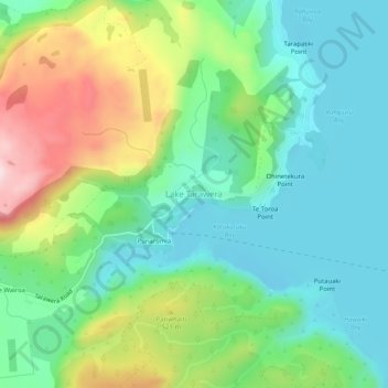
Name: Lake Tarawera topographic map, elevation, terrain.
Average elevation: 414 m
Minimum elevation: 290 m
Maximum elevation: 682 m
Other topographic maps
Click on a map to view its topography, its elevation and its terrain.
Te Whekau Lagoon
New Zealand > Bay of Plenty > Lake Tarawera
Te Whekau Lagoon, Spencer Road, Lake Tarawera, Rotorua District, Bay of Plenty, New Zealand
Average elevation: 393 m