
Thank you for supporting this site ❤️
Make a donation
Make a donation
Ohakune topographic map
Click on the map to display elevation.
Thank you for supporting this site ❤️
Make a donation
Make a donation
Ohakune
Ohakune is located in the Ruapehu District and the Manawatū-Whanganui region, to the immediate south-west of the slopes of the Mount Ruapehu stratovolcano. The town is 25 kilometres (16 miles) west of Waiouru, 70 kilometres (43 miles) northeast of Whanganui, 287 kilometres (178 miles) north of Wellington and 292 kilometres (181 miles) south of Auckland, and is at an elevation of 582 metres (1,909 ft).
Thank you for supporting this site ❤️
Make a donation
Make a donation
About this map
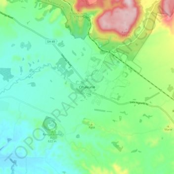
Name: Ohakune topographic map, elevation, terrain.
Average elevation: 619 m
Minimum elevation: 510 m
Maximum elevation: 909 m
Ruapehu District trails, hiking, mountain biking, running and outdoor activities
Thank you for supporting this site ❤️
Make a donation
Make a donation