
Oxford topographic map
Interactive map
Click on the map to display elevation.
About this map
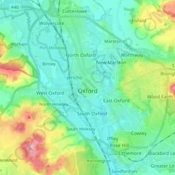
Name: Oxford topographic map, elevation, terrain.
Location: Oxford, Oxfordshire, England, United Kingdom (51.71098 -1.30425 51.79627 -1.17581)
Average elevation: 81 m
Minimum elevation: 50 m
Maximum elevation: 170 m
Other topographic maps
Click on a map to view its topography, its elevation and its terrain.
Wheatley
United Kingdom > England > Oxfordshire > South Oxfordshire
Wheatley, South Oxfordshire, Oxfordshire, England, United Kingdom
Average elevation: 90 m
Radley
United Kingdom > England > Oxfordshire > Vale of White Horse
Radley, Vale of White Horse, Oxfordshire, England, United Kingdom
Average elevation: 66 m
Kingston Bagpuize
United Kingdom > England > Oxfordshire > Vale of White Horse
Kingston Bagpuize, Vale of White Horse, Oxfordshire, England, OX13 5AH, United Kingdom
Average elevation: 76 m
Thame
United Kingdom > England > Oxfordshire > South Oxfordshire
Thame, South Oxfordshire, Oxfordshire, England, United Kingdom
Average elevation: 74 m
Stadhampton
United Kingdom > England > Oxfordshire > South Oxfordshire
Stadhampton, South Oxfordshire, Oxfordshire, England, United Kingdom
Average elevation: 61 m
Tusmore
United Kingdom > England > Oxfordshire > Cherwell District > Hardwick
Tusmore, Hardwick with Tusmore, Hardwick, Cherwell District, Oxfordshire, England, OX27 7SW, United Kingdom
Average elevation: 119 m
West Oxfordshire
United Kingdom > England > Oxfordshire
West Oxfordshire, Oxfordshire, England, United Kingdom
Average elevation: 119 m
Oxford
United Kingdom > England > Oxfordshire > Oxford
Oxford, Oxfordshire, South East England, England, OX1 3HY, United Kingdom
Average elevation: 81 m
Wantage
United Kingdom > England > Oxfordshire > Vale of White Horse > Wantage
Wantage, Vale of White Horse, Oxfordshire, South East England, England, United Kingdom
Average elevation: 151 m
Abingdon
United Kingdom > England > Oxfordshire > Vale of White Horse
Abingdon, Vale of White Horse, Oxfordshire, England, OX14 3UJ, United Kingdom
Average elevation: 64 m