
Havelock North topographic map
Interactive map
Click on the map to display elevation.
About this map
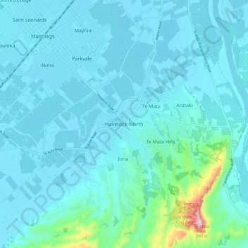
Name: Havelock North topographic map, elevation, terrain.
Average elevation: 45 m
Minimum elevation: 7 m
Maximum elevation: 391 m
Other topographic maps
Click on a map to view its topography, its elevation and its terrain.
Te Haroto
New Zealand > Hawke's Bay > Hastings District
Te Haroto, Hastings District, Hawke's Bay, New Zealand
Average elevation: 647 m
Hastings
New Zealand > Hawke's Bay > Hastings District
Hastings, Hastings District, Hawke's Bay, 4122, New Zealand
Average elevation: 68 m
Kereru
New Zealand > Hawke's Bay > Hastings District
Kereru, Hastings District, Hawke's Bay, New Zealand
Average elevation: 305 m
Poukawa
New Zealand > Hawke's Bay > Hastings District
Poukawa, Hastings District, Hawke's Bay, New Zealand
Average elevation: 49 m
Twyford
New Zealand > Hawke's Bay > Hastings District > Hastings
Twyford, Hastings, Hastings District, Hawke's Bay, 4154, New Zealand
Average elevation: 19 m
Waikoau
New Zealand > Hawke's Bay > Hastings District
Waikoau, Hastings District, Hawke's Bay, New Zealand
Average elevation: 290 m
Tutira
New Zealand > Hawke's Bay > Hastings District
Tutira, Hastings District, Hawke's Bay, New Zealand
Average elevation: 191 m
Mangateretere
New Zealand > Hawke's Bay > Hastings District > Hastings
Mangateretere, Hastings, Hastings District, Hawke's Bay, 4172, New Zealand
Average elevation: 9 m
Maraekakaho
New Zealand > Hawke's Bay > Hastings District > Maraekakaho
Maraekakaho, Hastings District, Hawke's Bay, New Zealand
Average elevation: 118 m
Matangi
New Zealand > Hawke's Bay > Hastings District > Hastings
Matangi, Hastings, Hastings District, Hawke's Bay, 4295, New Zealand
Average elevation: 187 m
Otatara Pā
New Zealand > Hawke's Bay > Hastings District > Napier > Waiohiki
Otatara Pā, Springfield Road, Waiohiki, Napier, Hastings District, Hawke's Bay, 4142, New Zealand
Average elevation: 31 m
Sherenden
New Zealand > Hawke's Bay > Hastings District > Sherenden
Sherenden, Hastings District, Hawke's Bay, New Zealand
Average elevation: 258 m
Lake Tutira
New Zealand > Hawke's Bay > Hastings District
Lake Tutira, Hastings District, Hawke's Bay, New Zealand
Average elevation: 197 m
Crownthorpe
New Zealand > Hawke's Bay > Hastings District
Crownthorpe, Hastings District, Hawke's Bay, New Zealand
Average elevation: 168 m
Maraetotara River
New Zealand > Hawke's Bay > Hastings District
Maraetotara River, Hastings District, Hawke's Bay, 4180, New Zealand
Average elevation: 105 m