
Fairlie topographic map
Interactive map
Click on the map to display elevation.
About this map
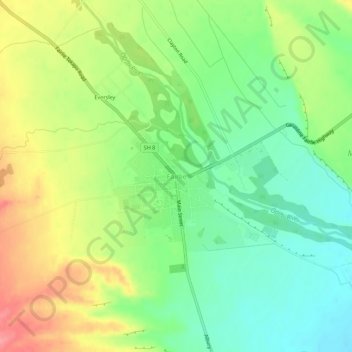
Name: Fairlie topographic map, elevation, terrain.
Location: Fairlie, Mackenzie District, Canterbury, 7925, New Zealand (-44.11758 170.80894 -44.07758 170.84894)
Average elevation: 317 m
Minimum elevation: 279 m
Maximum elevation: 371 m
Fairlie is a Mackenzie District service town (or township) located in the Canterbury region of the South Island of New Zealand. The estimated population was 930 as of June 2022. Being on state highway 8 between Christchurch (182 km, 2 hours 20 minutes drive) and Queenstown (300 km 3.5 hours drive), tourism is fast becoming a major industry within the town. Kimbell is 8 km west of Fairlie via state highway 8. Geraldine is 45 km east via state highway 79 and Timaru is 58 km southeast of Fairlie via state highway 8. Fairlie sits at an altitude of 301 metres above sea level.
Other topographic maps
Click on a map to view its topography, its elevation and its terrain.
Mount Blackburn
New Zealand > Canterbury > Mackenzie District
Mount Blackburn, Mackenzie District, Canterbury, New Zealand
Average elevation: 1,634 m
Twizel
New Zealand > Canterbury > Mackenzie District
Twizel, Mackenzie District, Canterbury, 7901, New Zealand
Average elevation: 472 m
Burkes Pass
New Zealand > Canterbury > Mackenzie District > Burkes Pass
Burkes Pass, Mackenzie District, Canterbury, New Zealand
Average elevation: 622 m
Mount Cook
New Zealand > Canterbury > Mackenzie District
Mount Cook, Mackenzie District, Canterbury, New Zealand
Average elevation: 2,920 m
Lake Benmore
New Zealand > Canterbury > Mackenzie District
Lake Benmore, Mackenzie District, Canterbury, New Zealand
Average elevation: 745 m
Lake Tekapo
New Zealand > Canterbury > Mackenzie District
Lake Tekapo, Mackenzie District, Canterbury, New Zealand
Average elevation: 1,025 m
Tasman Lake
New Zealand > Canterbury > Mackenzie District
Tasman Lake, Mackenzie District, Canterbury, New Zealand
Average elevation: 1,060 m
Lake Pukaki
New Zealand > Canterbury > Mackenzie District
Lake Pukaki, Mackenzie District, Canterbury, New Zealand
Average elevation: 886 m