
Naseby topographic map
Interactive map
Click on the map to display elevation.
About this map
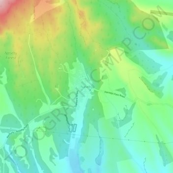
Name: Naseby topographic map, elevation, terrain.
Location: Naseby, Central Otago District, Otago, 9396, New Zealand (-45.04563 170.12782 -45.00563 170.16782)
Average elevation: 617 m
Minimum elevation: 538 m
Maximum elevation: 786 m
Naseby is a small town, formerly a borough, in the Maniototo area of Central Otago, New Zealand. It is named after a village in Northamptonshire, England. Previous names of the township were Parker's, Hogburn and Mt Ida. The town catch phrase is "2000 feet above worry level" indicating its altitude. Naseby is 395 km (5 hours drive) from Christchurch and 143 km (1 hour 45 minutes drive) from Dunedin.
Other topographic maps
Click on a map to view its topography, its elevation and its terrain.
Becks
New Zealand > Otago > Central Otago District > Vincent Community
Becks, Vincent Community, Central Otago District, Otago, 9377, New Zealand
Average elevation: 393 m
Cromwell
New Zealand > Otago > Central Otago District > Cromwell Community > Cromwell
Cromwell, Cromwell Community, Central Otago District, Otago, 9310, New Zealand
Average elevation: 330 m
Blue Lake
New Zealand > Otago > Central Otago District > Vincent Community > Saint Bathans
Blue Lake, Saint Bathans, Vincent Community, Central Otago District, Otago, New Zealand
Average elevation: 605 m
Kakanui Peak
New Zealand > Otago > Central Otago District
Kakanui Peak, Central Otago District, Otago, New Zealand
Average elevation: 1,169 m
Central Otago
New Zealand > Otago > Central Otago District > Vincent Community
Central Otago, Vincent Community, Central Otago District, Otago, 9035, New Zealand
Average elevation: 935 m
Shingle Creek
New Zealand > Otago > Central Otago District > Teviot Valley Community
Shingle Creek, Teviot Valley Community, Central Otago District, Otago, New Zealand
Average elevation: 307 m
Blackstone Hill
New Zealand > Otago > Central Otago District > Vincent Community
Blackstone Hill, Vincent Community, Central Otago District, Otago, 9377, New Zealand
Average elevation: 789 m
Alexandra
New Zealand > Otago > Central Otago District > Vincent Community
Alexandra, Vincent Community, Central Otago District, Otago, 9320, New Zealand
Average elevation: 241 m
Ranfurly
New Zealand > Otago > Central Otago District
Ranfurly, Central Otago District, Otago, 9332, New Zealand
Average elevation: 429 m
Ophir
New Zealand > Otago > Central Otago District > Vincent Community
Ophir, Vincent Community, Central Otago District, Otago, 9376, New Zealand
Average elevation: 338 m
Roxburgh
New Zealand > Otago > Central Otago District > Teviot Valley Community
Roxburgh, Teviot Valley Community, Central Otago District, Otago, 9500, New Zealand
Average elevation: 223 m
Clyde
New Zealand > Otago > Central Otago District > Vincent Community
Clyde, Vincent Community, Central Otago District, Otago, 9330, New Zealand
Average elevation: 316 m
Cromwell Community
New Zealand > Otago > Central Otago District
Cromwell Community, Central Otago District, Otago, New Zealand
Average elevation: 876 m
Ida Valley
New Zealand > Otago > Central Otago District > Maniototo Community
Ida Valley, Maniototo Community, Central Otago District, Otago, New Zealand
Average elevation: 472 m
Muttontown
New Zealand > Otago > Central Otago District > Vincent Community > Clyde
Muttontown, Clyde, Vincent Community, Central Otago District, Otago, 9391, New Zealand
Average elevation: 207 m
Millers Flat
New Zealand > Otago > Central Otago District > Teviot Valley Community
Millers Flat, Teviot Valley Community, Central Otago District, Otago, 9572, New Zealand
Average elevation: 161 m
Wedderburn
New Zealand > Otago > Central Otago District
Wedderburn, Central Otago District, Otago, 9395, New Zealand
Average elevation: 565 m