
North Connel topographic map
Interactive map
Click on the map to display elevation.
About this map
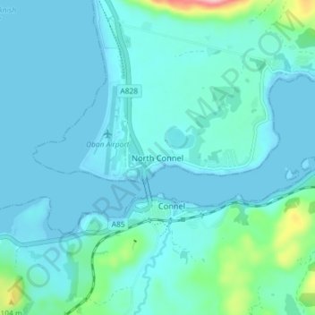
Name: North Connel topographic map, elevation, terrain.
Average elevation: 19 m
Minimum elevation: -1 m
Maximum elevation: 162 m
Other topographic maps
Click on a map to view its topography, its elevation and its terrain.
Helensburgh
United Kingdom > Scotland > Argyll and Bute
Helensburgh, Argyll and Bute, Scotland, G84 8SQ, United Kingdom
Average elevation: 63 m
Oban
United Kingdom > Scotland > Argyll and Bute > Oban
Oban, Argyll and Bute, Scotland, PA34 5PZ, United Kingdom
Average elevation: 47 m