Geolocate

Adair County topographic map

Interactive map

Click on the map to display elevation.

About this map

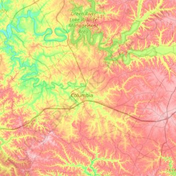
Name: Adair County topographic map, elevation, terrain.

Location: Adair County, Kentucky, USA (36.92544 -85.52709 37.31203 -85.04304)

Average elevation: 258 m

Minimum elevation: 164 m

Maximum elevation: 345 m

Other topographic maps

Click on a map to view its topography, its elevation and its terrain.

Robertson County

USA > Kentucky

Robertson County, Kentucky, 41064, USA

Average elevation: 239 m

Corbin

USA > Kentucky > Corbin

Corbin, Whitley County, Kentucky, USA

Average elevation: 360 m

Westwood

USA > Kentucky > Westwood

Westwood, Jefferson County, Kentucky, USA

Average elevation: 196 m

Madisonville

USA > Kentucky > Madisonville

Madisonville, Hopkins County, Kentucky, 42431, USA

Average elevation: 136 m

Stringtown

USA > Kentucky > Stringtown

Stringtown, Boone County, Kentucky, 45233, USA

Average elevation: 215 m

Music

USA > Kentucky > Music

Music, Carter County, Kentucky, USA

Average elevation: 264 m

Bell County

USA > Kentucky

Bell County, Kentucky, USA

Average elevation: 498 m

Pye

USA > Kentucky > Pye

Pye, Kenton County, Kentucky, 41015, USA

Average elevation: 210 m

Ulysses

USA > Kentucky > Ulysses

Ulysses, Lawrence County, Kentucky, 41264, USA

Average elevation: 238 m

Grayson County

USA > Kentucky

Grayson County, Kentucky, USA

Average elevation: 196 m

Mammoth Cave

USA > Kentucky > Mammoth Cave

Mammoth Cave, Edmonson County, Kentucky, USA

Average elevation: 214 m