
Guaira topographic map
Interactive map
Click on the map to display elevation.
About this map
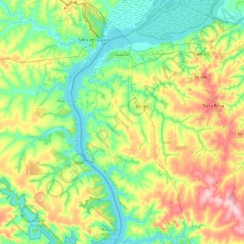
Name: Guaira topographic map, elevation, terrain.
Average elevation: 281 m
Minimum elevation: 215 m
Maximum elevation: 418 m
Guaíra is a municipality in the state of Paraná in the Southern Region of Brazil.[2] The population is 33,310 (2020 est.) in an area of 560 km².[3] The elevation is 517 m. This place name comes from the Tupi language and means "place difficult to access". The city is served by Guaíra Airport. It borders the Paraguayan city of Salto del Guairá, across the Paraná River, which marks the border between Brazil and Paraguay. Just like its Paraguayan twin city, it is named after the Guaíra Falls, which was located on the border with Paraguay. The falls was submerged after the construction of the Itaipu Dam in 1982.
Other topographic maps
Click on a map to view its topography, its elevation and its terrain.
Serranópolis do Iguaçu
Serranópolis do Iguaçu, Região Geográfica Imediata de Foz do Iguaçu, Região Geográfica Intermediária de Cascavel, Paraná, South Region, Brazil
Average elevation: 272 m
Guarapuava
Brazil > Paraná > Guarapuava
Guarapuava, Microrregião de Guarapuava, Mesorregião Centro Sul Paranaense, Paraná, South Region, Brazil
Average elevation: 1,017 m
Iguazu River
Brazil > Paraná > Capitão Leônidas Marques
Iguazu River, Capitão Leônidas Marques, Microrregião Cascavel, Mesorregião Oeste Paranaense, Paraná, South Region, Brazil
Average elevation: 308 m