
Hertfordshire topographic map
Interactive map
Click on the map to display elevation.
About this map
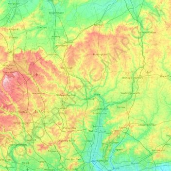
Name: Hertfordshire topographic map, elevation, terrain.
Location: Hertfordshire, East of England, England, United Kingdom (51.59958 -0.74579 52.08054 0.19557)
Average elevation: 82 m
Minimum elevation: 4 m
Maximum elevation: 243 m
In 2013, the county had a population of 1,140,700 in an area of 634 square miles (1,640 km2). Hemel Hempstead, Stevenage, Watford, and the only city in the county, St Albans have between 50,000 and 100,000 residents. Hertford, once the main market town for the medieval agricultural county, derives its name from a hart (stag) and a ford, used as the components of the county's coat of arms and flag. Elevations are high for the region in the north and west. These reach over 800 feet (240 m) in the western projection around Tring which is in the Chilterns. The county's borders are approximately the watersheds of the Colne and Lea; both flowing to the south; each accompanied by a canal. Hertfordshire's undeveloped land is mainly agricultural and much is protected by green belt.
Other topographic maps
Click on a map to view its topography, its elevation and its terrain.
Royal Tunbridge Wells
United Kingdom > England > Kent > Tunbridge Wells
Royal Tunbridge Wells, Tunbridge Wells, Kent, England, TN1 2DL, United Kingdom
Average elevation: 99 m
Fulham
Fulham, Greater London, England, SW6 5HJ, United Kingdom
Average elevation: 17 m
Epping
United Kingdom > England > Essex > Epping Forest > Ivy Chimneys
Epping, Ivy Chimneys, Epping Forest, Essex, England, United Kingdom
Average elevation: 84 m
Oxford
United Kingdom > England > Oxfordshire
Oxford, Oxfordshire, England, United Kingdom
Average elevation: 81 m
London
United Kingdom > England > London
London, Greater London, England, SW1A 2DX, United Kingdom
Average elevation: 42 m
Hayling Island
United Kingdom > England > Hampshire > Havant > North Hayling
Hayling Island, North Hayling, Havant, Hampshire, England, United Kingdom
Average elevation: 1 m
Didcot
United Kingdom > England > Oxfordshire > South Oxfordshire > East Hagbourne
Didcot, East Hagbourne, South Oxfordshire, Oxfordshire, England, United Kingdom
Average elevation: 61 m
Foston on the Wolds
United Kingdom > England > East Riding of Yorkshire
Foston on the Wolds, East Riding of Yorkshire, England, YO25 8BN, United Kingdom
Average elevation: 8 m
Hexham
United Kingdom > England > Northumberland
Hexham, Northumberland, North of Tyne, England, United Kingdom
Average elevation: 122 m
Ninebanks
United Kingdom > England > Northumberland
Ninebanks, West Allen, Northumberland, North of Tyne, England, NE47 8DA, United Kingdom
Average elevation: 341 m
Puttenham Common
United Kingdom > England > Surrey > Guildford > Puttenham
Puttenham Common, Murtmead Lane, Puttenham, Guildford, Surrey, England, GU3 1BQ, United Kingdom
Average elevation: 80 m
Ashbourne CP
United Kingdom > England > Derbyshire > Derbyshire Dales
Ashbourne CP, Derbyshire Dales, Derbyshire, England, United Kingdom
Average elevation: 147 m
Wheatley
United Kingdom > England > Oxfordshire > South Oxfordshire
Wheatley, South Oxfordshire, Oxfordshire, England, United Kingdom
Average elevation: 90 m
Brampton
United Kingdom > England > Cambridgeshire > Huntingdonshire > Brampton
Brampton, Huntingdonshire, Cambridgeshire, Cambridgeshire and Peterborough, England, United Kingdom
Average elevation: 22 m
Coleford
United Kingdom > England > Gloucestershire > Forest of Dean
Coleford, Forest of Dean, Gloucestershire, England, United Kingdom
Average elevation: 193 m
Upper Soudley
United Kingdom > England > Gloucestershire > Forest of Dean
Upper Soudley, Forest of Dean, Gloucestershire, England, GL14 2TS, United Kingdom
Average elevation: 138 m
St. Briavels
United Kingdom > England > Gloucestershire > Forest of Dean
St. Briavels, Forest of Dean, Gloucestershire, England, United Kingdom
Average elevation: 147 m
Brampton Abbotts
United Kingdom > England > Herefordshire
Brampton Abbotts, Herefordshire, England, United Kingdom
Average elevation: 60 m
Stockport
Stockport, Greater Manchester, England, United Kingdom
Average elevation: 95 m
Colyton
United Kingdom > England > Devon > East Devon
Colyton, East Devon, Devon, England, United Kingdom
Average elevation: 67 m
Radley
United Kingdom > England > Oxfordshire > Vale of White Horse
Radley, Vale of White Horse, Oxfordshire, England, United Kingdom
Average elevation: 66 m
Wiveliscombe
United Kingdom > England > Somerset
Wiveliscombe, Somerset, England, United Kingdom
Average elevation: 166 m
Little Clacton
United Kingdom > England > Essex
Little Clacton, Tendring, Essex, England, United Kingdom
Average elevation: 19 m
Staveley
United Kingdom > England > Westmorland and Furness
Staveley, Westmorland and Furness, England, LA8 9NW, United Kingdom
Average elevation: 171 m
Bisley
United Kingdom > England > Surrey > Surrey Heath > Bisley
Bisley, Surrey Heath, Surrey, England, United Kingdom
Average elevation: 46 m
Kellamergh
United Kingdom > England > Lancashire > Borough of Fylde > Warton
Kellamergh, Bryning-with-Warton, Warton, Borough of Fylde, Lancashire, England, PR4 1TL, United Kingdom
Average elevation: 14 m
Kingston Bagpuize
United Kingdom > England > Oxfordshire > Vale of White Horse
Kingston Bagpuize, Vale of White Horse, Oxfordshire, England, OX13 5AH, United Kingdom
Average elevation: 76 m
Rathmell
United Kingdom > England > North Yorkshire
Rathmell, North Yorkshire, England, BD24 0FG, United Kingdom
Average elevation: 172 m
Lynton
United Kingdom > England > Devon > North Devon > Lynbridge
Lynton, Lynton and Lynmouth, Lynbridge, North Devon, Devon, England, United Kingdom
Average elevation: 124 m
Kings Langley
United Kingdom > England > Hertfordshire > Dacorum
Kings Langley, Dacorum, Hertfordshire, England, United Kingdom
Average elevation: 111 m
Sourton
United Kingdom > England > Devon > West Devon
Sourton, West Devon, Devon, England, United Kingdom
Average elevation: 259 m
Hullbridge
United Kingdom > England > Essex > Rochford
Hullbridge, Rochford, Essex, England, SS5 6EU, United Kingdom
Average elevation: 14 m
Hoddesdon
United Kingdom > England > Hertfordshire
Hoddesdon, Broxbourne, Hertfordshire, England, EN11 8UD, United Kingdom
Average elevation: 54 m
New Ash Green
United Kingdom > England > Kent > Sevenoaks
New Ash Green, Sevenoaks, Kent, England, DA3 8JF, United Kingdom
Average elevation: 123 m
Maldon
United Kingdom > England > Maldon
Maldon, Essex, England, United Kingdom
Average elevation: 19 m
Thame
United Kingdom > England > Oxfordshire > South Oxfordshire
Thame, South Oxfordshire, Oxfordshire, England, United Kingdom
Average elevation: 74 m
Keighley
United Kingdom > England > Bradford > Long Lee
Keighley, Long Lee, Bradford, West Yorkshire, England, United Kingdom
Average elevation: 223 m
Birkenhead
Birkenhead, Wirral, Liverpool City Region, England, CH41 2XU, United Kingdom
Average elevation: 24 m
Nutfield
United Kingdom > England > Surrey > Tandridge
Nutfield, Tandridge, Surrey, England, United Kingdom
Average elevation: 88 m
College of St Hild and St Bede
United Kingdom > England > County Durham > Durham
College of St Hild and St Bede, Claypath, City of Durham, Durham, County Durham, North East, England, United Kingdom
Average elevation: 64 m
Stadhampton
United Kingdom > England > Oxfordshire > South Oxfordshire
Stadhampton, South Oxfordshire, Oxfordshire, England, United Kingdom
Average elevation: 61 m
Leigh upon Mendip
United Kingdom > England > Somerset
Leigh upon Mendip, Somerset, England, BA3 5QQ, United Kingdom
Average elevation: 177 m
Dorking
United Kingdom > England > Surrey > Mole Valley
Dorking, Mole Valley, Surrey, England, United Kingdom
Average elevation: 80 m
Blackfordby
United Kingdom > England > Leicestershire > North West Leicestershire
Blackfordby, North West Leicestershire, Leicestershire, England, DE11 8AP, United Kingdom
Average elevation: 135 m
Felbridge
United Kingdom > England > Surrey
Felbridge, Tandridge, Surrey, England, United Kingdom
Average elevation: 76 m
Harborne
United Kingdom > England > Birmingham
Harborne, Birmingham, West Midlands Combined Authority, England, B17 9JX, United Kingdom
Average elevation: 159 m
Mells
United Kingdom > England > Somerset
Mells, Somerset, England, United Kingdom
Average elevation: 133 m