
Climie topographic map
Interactive map
Click on the map to display elevation.
About this map
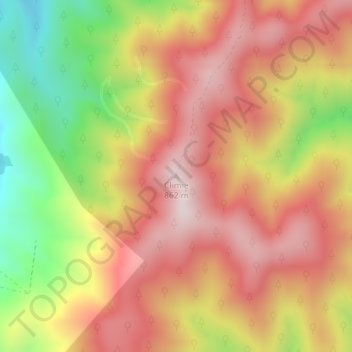
Name: Climie topographic map, elevation, terrain.
Average elevation: 609 m
Minimum elevation: 265 m
Maximum elevation: 856 m
Other topographic maps
Click on a map to view its topography, its elevation and its terrain.
Mangaroa River
New Zealand > Wellington > Upper Hutt
Mangaroa River, Upper Hutt, Upper Hutt City, Wellington, 5371, New Zealand
Average elevation: 283 m
Te Haukaretu Park
New Zealand > Wellington > Upper Hutt
Te Haukaretu Park, Maoribank, Upper Hutt, Upper Hutt City, Wellington, New Zealand
Average elevation: 113 m
Okupe Lagoon
New Zealand > Wellington > Upper Hutt
Okupe Lagoon, Boulder Bank Loop, Upper Hutt, Wellington, New Zealand
Average elevation: 26 m
Akatarawa River
New Zealand > Wellington > Upper Hutt
Akatarawa River, Upper Hutt, Upper Hutt City, Wellington, 6007, New Zealand
Average elevation: 428 m
Whakatikei River
New Zealand > Wellington > Upper Hutt
Whakatikei River, Upper Hutt, Upper Hutt City, Wellington, 5018, New Zealand
Average elevation: 316 m
Pakuratahi River
New Zealand > Wellington > Upper Hutt
Pakuratahi River, Upper Hutt, Upper Hutt City, Wellington, New Zealand
Average elevation: 353 m
Eastern Hutt River
New Zealand > Wellington > Upper Hutt
Eastern Hutt River, Upper Hutt, Upper Hutt City, Wellington, New Zealand
Average elevation: 817 m