
Sint Eustatius topographic map
Interactive map
Click on the map to display elevation.
About this map
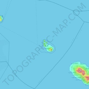
Name: Sint Eustatius topographic map, elevation, terrain.
Location: Sint Eustatius, Netherlands (17.27673 -63.19861 17.72699 -62.78471)
Average elevation: 12 m
Minimum elevation: 0 m
Maximum elevation: 1,044 m
Sint Eustatius is 6 miles (10 km) long and up to 3 miles (5 km) wide. Topographically, the island is saddle-shaped, with the 602 meter-high dormant volcano Quill (Mount Mazinga), (from Dutch kuil, meaning 'pit'—originally referring to its crater) to the southeast and the smaller pair of Signal Hill/Little Mountain (or Bergje) and Boven Mountain to the northwest. The Quill crater is a popular tourist attraction on the island. The bulk of the island's population lives in the flat saddle between the two elevated areas, which forms the centre of the island.
Other topographic maps
Click on a map to view its topography, its elevation and its terrain.
Ruigoord
Netherlands > North Holland > Amsterdam
Ruigoord, Westpoort, Amsterdam, North Holland, Netherlands, 1047 HH, Netherlands
Average elevation: 0 m
Bussum
Bussum, Gooise Meren, North Holland, Netherlands
Average elevation: 5 m
Gendringen
Gendringen, Oude IJsselstreek, Gelderland, Netherlands
Average elevation: 16 m
Zuidlaren
Netherlands > Drenthe > Zuidlaren
Zuidlaren, Tynaarlo, Drenthe, Netherlands
Average elevation: 5 m
Leeward Islands
Leeward Islands, Zions Hill, Saba, Netherlands
Average elevation: 112 m
Maastricht
Netherlands > Limburg > Maastricht
Maastricht, Limburg, Netherlands, 6211CS, Netherlands
Average elevation: 101 m
Dokkum
Netherlands > Friesland > Dokkum
Dokkum, Noardeast-Fryslân, Friesland, Netherlands
Average elevation: 0 m
Capelle aan den IJssel
Netherlands > South Holland > Capelle aan den IJssel
Capelle aan den IJssel, Rotterdam, South Holland, Netherlands
Average elevation: -1 m
Sneek
Netherlands > Friesland > Sneek
Sneek, Súdwest-Fryslân, Friesland, Netherlands
Average elevation: 0 m
Alphen aan den Rijn
Alphen aan den Rijn, South Holland, Netherlands
Average elevation: -2 m
Nijverdal
Netherlands > Overijssel > Nijverdal
Nijverdal, Hellendoorn, Overijssel, Netherlands
Average elevation: 18 m
Harderwijk
Netherlands > Gelderland > Harderwijk
Harderwijk, Gelderland, Netherlands
Average elevation: 5 m
Son en Breugel
Netherlands > North Brabant > Son en Breugel
Son en Breugel, North Brabant, Netherlands
Average elevation: 15 m
Overveen
Netherlands > North Holland > Overveen
Overveen, Bloemendaal, North Holland, Netherlands
Average elevation: 6 m
Bilthoven
Netherlands > Utrecht > Bilthoven
Bilthoven, De Bilt, Utrecht, Netherlands
Average elevation: 5 m
Gouda
Netherlands > South Holland > Haastrecht
Gouda, Haastrecht, Krimpenerwaard, South Holland, Netherlands
Average elevation: -1 m
Nieuw-Schoonebeek
Netherlands > Drenthe > Nieuw-Schoonebeek
Nieuw-Schoonebeek, Emmen, Drenthe, Netherlands
Average elevation: 17 m
Rozendaal
Netherlands > Gelderland > Rozendaal
Rozendaal, Rheden, Gelderland, Netherlands
Average elevation: 66 m
Halsteren
Netherlands > North Brabant > Bergen op Zoom > Halsteren
Halsteren, Bergen op Zoom, North Brabant, Netherlands
Average elevation: 3 m
Acquoy
Netherlands > Gelderland > Acquoy
Acquoy, West Betuwe, Gelderland, Netherlands
Average elevation: 2 m
Rijswijk
Netherlands > South Holland > Rijswijk
Rijswijk, South Holland, Netherlands
Average elevation: 2 m
Overasselt
Netherlands > Gelderland > Overasselt
Overasselt, Heumen, Gelderland, Netherlands
Average elevation: 10 m
Wageningen
Netherlands > Gelderland > Wageningen
Wageningen, Gelderland, Netherlands
Average elevation: 14 m
Eerbeek
Netherlands > Gelderland > Eerbeek
Eerbeek, Brummen, Gelderland, Netherlands
Average elevation: 23 m