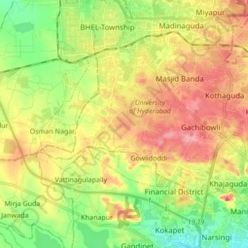
Ward 105 Gachibowli topographic map
Interactive map
Click on the map to display elevation.
About this map
Name: Ward 105 Gachibowli topographic map, elevation, terrain.
Average elevation: 568 m
Minimum elevation: 517 m
Maximum elevation: 625 m

Click on the map to display elevation.
Name: Ward 105 Gachibowli topographic map, elevation, terrain.
Average elevation: 568 m
Minimum elevation: 517 m
Maximum elevation: 625 m