
Jostedalsbreen topographic map
Interactive map
Click on the map to display elevation.
About this map
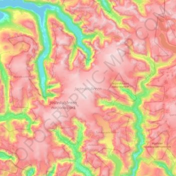
Name: Jostedalsbreen topographic map, elevation, terrain.
Location: Jostedalsbreen, Stryn, Sogn og Fjordane, Norway (61.47261 6.67247 61.88659 7.48804)
Average elevation: 1,127 m
Minimum elevation: 0 m
Maximum elevation: 2,032 m
Other topographic maps
Click on a map to view its topography, its elevation and its terrain.
Beitostølen
Beitostølen, Øystre Slidre, Innlandet, 2953, Norway
Average elevation: 914 m
Finnmark
Finnmark, Bamble, Vestfold og Telemark, 3967, Norway
Average elevation: 38 m
Norway
Norway > Hamningberg > Apalen
Norway, Øvre Tveit, Apalen, Askøy, Hordaland, 5310, Norway
Average elevation: 143 m
Honningsvåg
Honningsvåg, Nordkapp, Troms og Finnmark, 9750, Norway
Average elevation: 68 m
Nedre Eggedal
Nedre Eggedal, Sigdal, Buskerud, 3358, Norway
Average elevation: 286 m