
Morris County topographic map
Interactive map
Click on the map to display elevation.
About this map
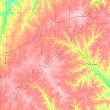
Name: Morris County topographic map, elevation, terrain.
Location: Morris County, Kansas, USA (38.52263 -96.93115 38.87189 -96.35329)
Average elevation: 428 m
Minimum elevation: 339 m
Maximum elevation: 476 m
Other topographic maps
Click on a map to view its topography, its elevation and its terrain.
Lake Jeanette
USA > Kansas > Leavenworth
Lake Jeanette, Lakeside Drive, Leavenworth, Leavenworth County, Kansas, 66043, USA
Average elevation: 253 m
Independence
USA > Kansas > Independence
Independence, Montgomery County, Kansas, 67301, USA
Average elevation: 245 m