
Ben Nevis topographic map
Interactive map
Click on the map to display elevation.
About this map
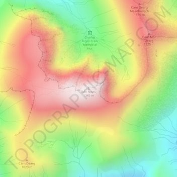
Name: Ben Nevis topographic map, elevation, terrain.
Location: Ben Nevis, Highland, Scotland, United Kingdom (56.79681 -5.00358 56.79691 -5.00348)
Average elevation: 912 m
Minimum elevation: 474 m
Maximum elevation: 1,338 m
Ben Nevis has a highland (alpine) maritime (oceanic) polar climate (ET climate in the Köppen classification). Ben Nevis's elevation, maritime location and topography frequently lead to cool and cloudy weather conditions, which can pose a danger to ill-equipped walkers. According to the observations carried out at the summit observatory from 1883–1904, fog was present on the summit for almost 80% of the time between November and January, and 55% of the time in May and June. The average winter temperature was around −5 °C (23 °F), and the mean monthly temperature for the year was −0.5 °C (31.1 °F). In an average year the summit sees 261 gales, and receives 4,350 millimetres (171 in) of rainfall, compared to only 2,050 millimetres (81 in) in nearby Fort William, 840 millimetres (33 in) in Inverness and 580 millimetres (23 in) in London. Rainfall on Ben Nevis is about twice as high in the winter as it is in the spring and summer. Snow can be found on the mountain almost all year round, particularly in the gullies of the north face – with the higher reaches of Observatory Gully holding snow until September most years and sometimes until the new snows of the following season.
Other topographic maps
Click on a map to view its topography, its elevation and its terrain.
Dores
United Kingdom > Scotland > Highland
Dores, Highland, Scotland, IV2 6TT, United Kingdom
Average elevation: 106 m
Drumchork
United Kingdom > Scotland > Highland > Aultbea
Drumchork, Aultbea, Highland, Scotland, IV22 2HU, United Kingdom
Average elevation: 50 m
Strathpeffer
United Kingdom > Scotland > Highland
Strathpeffer, Highland, Scotland, IV14 9DW, United Kingdom
Average elevation: 127 m
Kilmore
United Kingdom > Scotland > Highland > Ferindonald
Kilmore, Sleat, Ferindonald, Highland, Scotland, IV44 8RG, United Kingdom
Average elevation: 61 m
Scottish Highlands
United Kingdom > Scotland > Highland
Scottish Highlands, Highland, Scotland, United Kingdom
Average elevation: 907 m
Inverness
United Kingdom > Scotland > Highland
Inverness, Highland, Scotland, IV1 1AN, United Kingdom
Average elevation: 163 m
Grampian Mountains
United Kingdom > Scotland > Highland
Grampian Mountains, Highland, Scotland, United Kingdom
Average elevation: 775 m