
Xiamen City topographic map
Interactive map
Click on the map to display elevation.
About this map
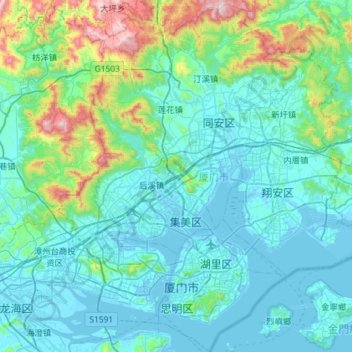
Name: Xiamen City topographic map, elevation, terrain.
Location: Xiamen City, Fujian, China (24.42394 117.87582 24.90942 118.41005)
Average elevation: 176 m
Minimum elevation: -5 m
Maximum elevation: 1,132 m
Other topographic maps
Click on a map to view its topography, its elevation and its terrain.
Xiamen City
China > Fujian > Xiamen > Yundang Subdistrict
Xiamen City, Yundang Subdistrict, Siming District, Xiamen, Fujian, 361000, China
Average elevation: 29 m