
Als topographic map
Interactive map
Click on the map to display elevation.
About this map
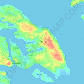
Name: Als topographic map, elevation, terrain.
Average elevation: 8 m
Minimum elevation: -8 m
Maximum elevation: 74 m
Other topographic maps
Click on a map to view its topography, its elevation and its terrain.
Esbjerg
Denmark > Region of Southern Denmark
Esbjerg, Esbjerg Municipality, Region of Southern Denmark, 6700, Denmark
Average elevation: 7 m
Kolding
Denmark > Region of Southern Denmark > Kolding
Kolding, Kolding Municipality, Region of Southern Denmark, 6000, Denmark
Average elevation: 39 m
Vejle
Denmark > Region of Southern Denmark > Vejle
Vejle, Vejle Municipality, Region of Southern Denmark, 7100, Denmark
Average elevation: 60 m
Aabenraa
Denmark > Region of Southern Denmark
Aabenraa, Aabenraa Municipality, Region of Southern Denmark, 6200, Denmark
Average elevation: 36 m
Odense
Denmark > Region of Southern Denmark > Odense
Odense, Odense Kommune, Region of Southern Denmark, 5000, Denmark
Average elevation: 30 m
Fyn
Denmark > Region of Southern Denmark > Odense
Fyn, Odense, Odense Kommune, Region of Southern Denmark, Denmark
Average elevation: 19 m