
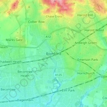
Romford topographic map
Interactive map
Click on the map to display elevation.
About this map
Name: Romford topographic map, elevation, terrain.
Location: Romford, Greater London, England, RM1 1RX, United Kingdom (51.53605 0.14226 51.61605 0.22226)
Average elevation: 29 m
Minimum elevation: 1 m
Maximum elevation: 109 m
The town centre is about 50 feet (15 m) above sea level on a gravel terrace rising from the River Thames. The north of the town has developed on London Clay and is situated as much as 150 ft (46 m) above sea level. A continuous gentle rise in the eastern suburbs towards Gidea Park and Harold Wood peaks around 177 feet (54 m) around the Harold Court. On the northern side, Harold Hill peaks at 75 m (246 ft). The semi-rural area north of Collier Row and Harold Hill consists of many rolls of hills, with elevation peaking at the village of Havering-atte-Bower, 344 feet (105 m). The town centre is for the most part contained within a ring road formed of St Edwards Way, Mercury Gardens, Thurloe Gardens, Oldchurch Road and Waterloo Road. The market place and much of South Street and the High Street are pedestrianised. The railway cuts through the town from east to west on a viaduct, with the bulk of the central Romford area to its north. The River Rom flows through the town in underground channels and joins the Thames after flowing through Hornchurch; elsewhere along its course it is known as the River Beam and forms part of the strategic waterways Blue Ribbon Network. Romford has formed part of the continuously built-up area of London since the 1930s and is contiguous with Rush Green to the west, Collier Row to the north, Gidea Park to the east and Hornchurch to the south east.
Other topographic maps
Click on a map to view its topography, its elevation and its terrain.
London
United Kingdom > England > London
London, Greater London, England, SW1A 2DX, United Kingdom
Average elevation: 42 m
London
London, Greater London, England, United Kingdom
Average elevation: 66 m
Bristol
United Kingdom > England > City of Bristol
Bristol, City of Bristol, West of England, England, United Kingdom
Average elevation: 55 m
Winchester
United Kingdom > England > Hampshire
Winchester, Hampshire, England, United Kingdom
Average elevation: 73 m
Greater Manchester
Greater Manchester, England, United Kingdom
Average elevation: 141 m
Oxford
United Kingdom > England > Oxfordshire
Oxford, Oxfordshire, England, United Kingdom
Average elevation: 81 m
Skipton
United Kingdom > England > Skipton
Skipton, North Yorkshire, Yorkshire and the Humber, England, BD23 1DU, United Kingdom
Average elevation: 201 m
Sheffield
Sheffield, South Yorkshire, England, United Kingdom
Average elevation: 168 m
Hull
United Kingdom > England > Kingston upon Hull
Hull, Kingston upon Hull, England, HU1 3RJ, United Kingdom
Average elevation: 21 m
Nottingham
United Kingdom > England > Nottinghamshire
Nottingham, England, United Kingdom
Average elevation: 56 m
East of England
East of England, England, United Kingdom
Average elevation: 39 m
Dorset
United Kingdom > England > Talbot Village
Dorset, Alder Road, Branksome, Talbot Village, Bournemouth, Christchurch and Poole, South West England, England, BH12 5BJ, United Kingdom
Average elevation: 57 m
East Riding of Yorkshire
East Riding of Yorkshire, England, United Kingdom
Average elevation: 30 m
Cambridge
United Kingdom > England > Cambridge
Cambridge, Cambridgeshire, East of England, England, United Kingdom
Average elevation: 18 m
Hastings
United Kingdom > England > East Sussex
Hastings, East Sussex, England, United Kingdom
Average elevation: 36 m
Liverpool
Liverpool, Liverpool City Region, England, United Kingdom
Average elevation: 26 m
Torquay
United Kingdom > England > Torbay
Torquay, Torbay, England, TQ1 1TR, United Kingdom
Average elevation: 31 m
Lake District National Park
Lake District National Park, England, United Kingdom
Average elevation: 206 m
Bath
United Kingdom > England > Bath and North East Somerset
Bath, Bath and North East Somerset, West of England, England, United Kingdom
Average elevation: 100 m
Stroud
United Kingdom > England > Gloucestershire
Stroud, Gloucestershire, England, United Kingdom
Average elevation: 113 m
Norwich
United Kingdom > England > Norfolk
Norwich, Norfolk, England, United Kingdom
Average elevation: 28 m
Kent
United Kingdom > England > Sevenoaks
Kent, Beechenlea Lane, Swanley, Sevenoaks, Kent, South East, England, BR8 7PR, United Kingdom
Average elevation: 37 m
North Norfolk
United Kingdom > England > Norfolk
North Norfolk, Norfolk, England, United Kingdom
Average elevation: 26 m
Warminster
United Kingdom > England > Wiltshire
Warminster, Wiltshire, England, United Kingdom
Average elevation: 143 m
City of London
United Kingdom > England > City of London > City of London
City of London, England, EC2V 5AE, United Kingdom
Average elevation: 42 m
North Yorkshire
North Yorkshire, Yorkshire and the Humber, England, United Kingdom
Average elevation: 153 m
Somerset
Somerset, South West England, England, United Kingdom
Average elevation: 87 m
Coventry
Coventry, West Midlands Combined Authority, England, United Kingdom
Average elevation: 99 m
Newcastle upon Tyne
Newcastle upon Tyne, North of Tyne, England, United Kingdom
Average elevation: 57 m
Plymouth
United Kingdom > England > Devon > Plymouth
Plymouth, Devon, South West England, England, PL1 1HH, United Kingdom
Average elevation: 81 m
Peterborough
United Kingdom > England > City of Peterborough
Peterborough, City of Peterborough, Cambridgeshire and Peterborough, England, PE1 1XH, United Kingdom
Average elevation: 17 m
Sharpness
United Kingdom > England > Gloucestershire > Stroud
Sharpness, Stroud, Gloucestershire, England, GL13 9PE, United Kingdom
Average elevation: 17 m
Skirpenbeck
United Kingdom > England > East Riding of Yorkshire
Skirpenbeck, East Riding of Yorkshire, England, United Kingdom
Average elevation: 28 m
Dartmoor National Park
United Kingdom > England > Devon
Dartmoor National Park, Devon, England, United Kingdom
Average elevation: 239 m
Hampshire
Hampshire, South East, England, United Kingdom
Average elevation: 73 m
Holmfirth
United Kingdom > England > Kirklees
Holmfirth, Kirklees, West Yorkshire, England, HD9 7DE, United Kingdom
Average elevation: 260 m
Bradford
Bradford, West Yorkshire, England, United Kingdom
Average elevation: 175 m
Birmingham
Birmingham, West Midlands Combined Authority, England, United Kingdom
Average elevation: 138 m