
Port Vila topographic map
Interactive map
Click on the map to display elevation.
About this map
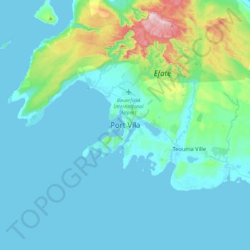
Name: Port Vila topographic map, elevation, terrain.
Location: Port Vila, Shefa Province, Vanuatu (-17.90150 168.15502 -17.58150 168.47502)
Average elevation: 82 m
Minimum elevation: 0 m
Maximum elevation: 635 m
Other topographic maps
Click on a map to view its topography, its elevation and its terrain.
Nguna
Vanuatu > Shefa Province > Port Vila
Nguna, Port Vila, Shefa Province, Vanuatu
Average elevation: 75 m
Emae Island
Vanuatu > Shefa Province > Port Vila
Emae Island, Port Vila, Shefa Province, Vanuatu
Average elevation: 33 m