
Newton County topographic map
Interactive map
Click on the map to display elevation.
About this map
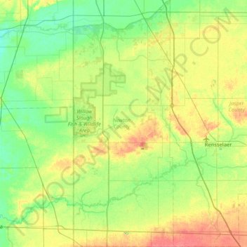
Name: Newton County topographic map, elevation, terrain.
Location: Newton County, Indiana, USA (40.73651 -87.52663 41.21867 -87.26641)
Average elevation: 205 m
Minimum elevation: 187 m
Maximum elevation: 238 m
Other topographic maps
Click on a map to view its topography, its elevation and its terrain.
Wilson Wisely Ditch
Wilson Wisely Ditch, Pulaski County, Indiana, USA
Average elevation: 220 m
Middle Fork of Wildcat Creek
Middle Fork of Wildcat Creek, Clinton County, Indiana, 46065, USA
Average elevation: 215 m
Lake Windemere
Lake Windemere, Sedgemoor Circle, North Augusta Addition, Carmel, Hamilton County, Indiana, 46032, USA
Average elevation: 273 m