
Bentong topographic map
Interactive map
Click on the map to display elevation.
About this map
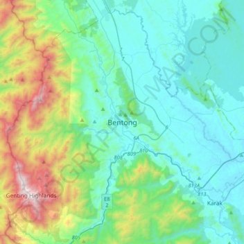
Name: Bentong topographic map, elevation, terrain.
Location: Bentong, Pahang, 28700, Malaysia (3.36093 101.75062 3.68093 102.07062)
Average elevation: 412 m
Minimum elevation: 45 m
Maximum elevation: 1,760 m
Other topographic maps
Click on a map to view its topography, its elevation and its terrain.
Sungai Benus
Sungai Benus, Bentong, Pahang, Malaysia
Average elevation: 512 m