
Koshi topographic map
Interactive map
Click on the map to display elevation.
About this map
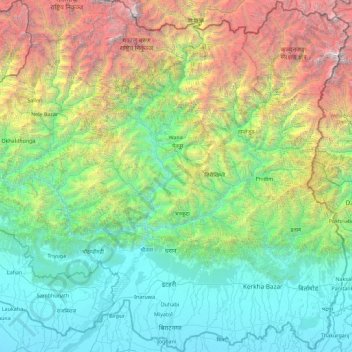
Name: Koshi topographic map, elevation, terrain.
Location: Koshi, Eastern Development Region, Nepal (26.34776 86.89317 27.95792 87.75151)
Average elevation: 1,899 m
Minimum elevation: 55 m
Maximum elevation: 8,489 m
Other topographic maps
Click on a map to view its topography, its elevation and its terrain.
Mount Everest
Nepal > Eastern Development Region > Tashi Dzom > Khumjung
Mount Everest, Khumjung, Khumbupasanglahmu, Solukhumbu, Province #1, Nepal
Average elevation: 7,839 m
Lhotse Shar
Nepal > Eastern Development Region > Khumjung
Lhotse Shar, Khumjung, Solukhumbu, Sagarmatha, Eastern Development Region, Nepal
Average elevation: 7,153 m
Ngozumpa Glacier
Nepal > Eastern Development Region > Khumjung > Khumjung
Ngozumpa Glacier, Khumjung, Solukhumbu, Sagarmatha, Eastern Development Region, Nepal
Average elevation: 5,632 m
Eastern Development Region
Nepal > Eastern Development Region
Eastern Development Region, Nepal
Average elevation: 2,220 m
Sagarmatha
Nepal > Eastern Development Region
Sagarmatha, Eastern Development Region, Nepal
Average elevation: 1,771 m
Khumbu Glacier
Nepal > Eastern Development Region > Khumjung > Khumjung
Khumbu Glacier, Khumjung, Solukhumbu, Sagarmatha, Eastern Development Region, Nepal
Average elevation: 6,297 m
Mechi
Nepal > Eastern Development Region
Mechi, Eastern Development Region, Nepal
Average elevation: 1,902 m