
Mount Taranaki topographic map
Interactive map
Click on the map to display elevation.
About this map
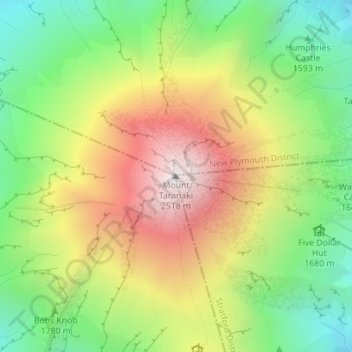
Name: Mount Taranaki topographic map, elevation, terrain.
Location: Mount Taranaki, Stratford District, Taranaki, New Zealand (-39.29613 174.06384 -39.29603 174.06394)
Average elevation: 1,847 m
Minimum elevation: 1,328 m
Maximum elevation: 2,495 m
Other topographic maps
Click on a map to view its topography, its elevation and its terrain.
Stratford
New Zealand > Taranaki > Stratford District
Stratford, Stratford District, Taranaki, 4332, New Zealand
Average elevation: 310 m