
Huntly topographic map
Interactive map
Click on the map to display elevation.
About this map
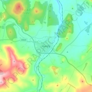
Name: Huntly topographic map, elevation, terrain.
Location: Huntly, Aberdeenshire, Scotland, AB54 8AE, United Kingdom (57.40748 -2.82642 57.48748 -2.74642)
Average elevation: 171 m
Minimum elevation: 91 m
Maximum elevation: 387 m
Other topographic maps
Click on a map to view its topography, its elevation and its terrain.
Knock Hill
United Kingdom > Scotland > Aberdeenshire
Knock Hill, Aberdeenshire, Scotland, AB39 3YB, United Kingdom
Average elevation: 127 m
St Cyrus
United Kingdom > Scotland > Aberdeenshire
St Cyrus, Aberdeenshire, Scotland, DD10 0BG, United Kingdom
Average elevation: 63 m
Kinneff
United Kingdom > Scotland > Aberdeenshire > Inverbervie
Kinneff, Inverbervie, Aberdeenshire, Scotland, DD10 0TJ, United Kingdom
Average elevation: 48 m
Collieston
United Kingdom > Scotland > Aberdeenshire > Collieston
Collieston, Aberdeenshire, Scotland, AB41 8RT, United Kingdom
Average elevation: 23 m