
Nassau County topographic map
Interactive map
Click on the map to display elevation.
About this map
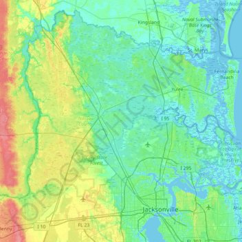
Name: Nassau County topographic map, elevation, terrain.
Location: Nassau County, Florida, United States of America (30.27334 -82.05043 30.83020 -81.34636)
Average elevation: 13 m
Minimum elevation: -4 m
Maximum elevation: 59 m
There are 12 distinct topographical zones in Nassau County. Most of these zones run in narrow bands stretching from north to south, although this is less true as one approaches the Atlantic coast.
Other topographic maps
Click on a map to view its topography, its elevation and its terrain.
Dunnellon
United States of America > Florida > Dunnellon
Dunnellon, Marion County, Florida, 34434, United States of America
Average elevation: 21 m
Riverview
United States of America > Florida > Riverview
Riverview, Hillsborough County, Florida, 33578, United States of America
Average elevation: 13 m
Compass Lake
United States of America > Florida > Compass Lake
Compass Lake, Jackson County, Florida, 32420, United States of America
Average elevation: 66 m
Pinellas County
United States of America > Florida
Pinellas County, Florida, United States of America
Average elevation: 4 m
Pasco County
United States of America > Florida
Pasco County, Florida, United States of America
Average elevation: 18 m
Key West
United States of America > Florida > Key West > Key West
Key West, Monroe, Florida, 33040, United States of America
Average elevation: 1 m
Altamonte Springs
United States of America > Florida > Altamonte Springs
Altamonte Springs, Seminole County, Florida, United States of America
Average elevation: 26 m
Sumter County
United States of America > Florida
Sumter County, Florida, United States of America
Average elevation: 27 m
Coconut Creek
United States of America > Florida > Coconut Creek
Coconut Creek, Broward County, Florida, United States of America
Average elevation: 7 m
Miami-Dade County
United States of America > Florida
Miami-Dade County, Florida, United States of America
Average elevation: 3 m
Lake Alice
United States of America > Florida > Gainesville
Lake Alice, Museum Road, Daysville, Gainesville, Alachua County, Florida, 32601, United States of America
Average elevation: 30 m
Hendry County
United States of America > Florida
Hendry County, Florida, United States of America
Average elevation: 8 m
Collier County
United States of America > Florida
Collier County, Florida, United States of America
Average elevation: 5 m
St. Augustine
United States of America > Florida > St. Augustine
St. Augustine, St. Johns County, Florida, 32084, United States of America
Average elevation: 5 m