
South Sumatra topographic map
Interactive map
Click on the map to display elevation.
About this map
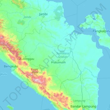
Name: South Sumatra topographic map, elevation, terrain.
Location: South Sumatra, Sumatra, Indonesia (-4.92416 102.05323 -1.51384 106.60263)
Average elevation: 123 m
Minimum elevation: -3 m
Maximum elevation: 2,774 m
On the east coast the land consists of swamps and brackets which are affected by tides. Its vegetation is in the form of palmate plants and mangrove. A little more western is a vast lowland. Far to the west near the border of Bengkulu and Jambi lies the Bukit Barisan mountains, which divides South Sumatra and is a mountainous area with an altitude of 900 to 1,200 metres (3,000 to 3,900 ft) above sea level. Barisan Hill consists of the summit of Mount Seminung (1,964 metres or 6,444 feet asl), Mount Dempo (3,159 metres or 10,364 feet asl), Mount Patah (1,107 metres or 3,632 feet asl), and Mount Bungkuk (2,125 metres or 6,972 feet asl). To the west of Bukit Barisan is a slope. In the Bukit Barisan valley there are areas of rubber, oil palm, and agriculture plantations, especially coffee, tea and vegetables. Mount Dempo is the highest point in the province.
Other topographic maps
Click on a map to view its topography, its elevation and its terrain.
Mount Marapi
Indonesia > West Sumatra > Agam
Mount Marapi, Agam, West Sumatra, Sumatra, Indonesia
Average elevation: 2,457 m
Krakatoa
Indonesia > Lampung > Lampung Selatan
Krakatoa, Lampung Selatan, Lampung, Sumatra, Indonesia
Average elevation: 20 m
Malalak Selatan
Indonesia > West Sumatra > Padang Pariaman
Malalak Selatan, Padang Pariaman, West Sumatra, Sumatra, Indonesia
Average elevation: 651 m
Wareng
Indonesia > Special Region of Yogyakarta > Gunung Kidul Regency
Wareng, Wonosari, Gunung Kidul Regency, Special Region of Yogyakarta, Java, Indonesia
Average elevation: 178 m
Kawasan Wisata Ollon
Indonesia > South Sulawesi > LEMBANG BAU BUAKAYU
Kawasan Wisata Ollon, LEMBANG BAU BUAKAYU, Tana Toraja Regency, South Sulawesi, Sulawesi, Indonesia
Average elevation: 302 m
Rantepao
Indonesia > South Sulawesi > Toraja Utara
Rantepao, Toraja Utara, South Sulawesi, Sulawesi, 91831, Indonesia
Average elevation: 848 m
Malang
Indonesia > East Java > Kota Malang
Malang, Kota Malang, East Java, Java, Indonesia
Average elevation: 490 m
Bokondini
Indonesia > Highland Papua > Tolikara
Bokondini, Tolikara, Highland Papua, Western New Guinea, Indonesia
Average elevation: 1,456 m
Sungai Abang
Indonesia > Jambi > Batanghari > Rantau Kapas Tuo
Sungai Abang, Rantau Kapas Tuo, Pasar Muara Tembesi, Batanghari, Jambi, Sumatra, Indonesia
Average elevation: 20 m
Lau Labi
Indonesia > North Sumatra > Deli Serdang > Cinta Rakyat
Lau Labi, Cinta Rakyat, Deli Serdang, North Sumatra, Sumatra, 20357, Indonesia
Average elevation: 903 m
Kota Baru
Indonesia > South Sumatra > Penukal Abab Lematang Ilir
Kota Baru, Penukal Utara, Penukal Abab Lematang Ilir, South Sumatra, Sumatra, Indonesia
Average elevation: 44 m
Sumbawa
Indonesia > West Nusa Tenggara
Sumbawa, West Nusa Tenggara, Lesser Sunda Islands, Indonesia
Average elevation: 79 m
East Nusa Tenggara
East Nusa Tenggara, Lesser Sunda Islands, Indonesia
Average elevation: 31 m
Calaca
Indonesia > North Sulawesi > Manado
Calaca, Manado, North Sulawesi, Sulawesi, 95122, Indonesia
Average elevation: 11 m
Wakatobi
Indonesia > Southeast Sulawesi
Wakatobi, Southeast Sulawesi, Sulawesi, Indonesia
Average elevation: 4 m
Palangka Raya
Indonesia > Central Kalimantan
Palangka Raya, Central Kalimantan, Kalimantan, Indonesia
Average elevation: 23 m
Makete
Indonesia > North Maluku > Halmahera Utara
Makete, Halmahera Utara, North Maluku, Maluku, Indonesia
Average elevation: 32 m
Kuta
Indonesia > West Nusa Tenggara > Lombok Tengah
Kuta, Lombok Tengah, West Nusa Tenggara, Lesser Sunda Islands, 83573, Indonesia
Average elevation: 34 m
Oson
Indonesia > Moluccas > Seram Bagian Timur
Oson, Seram Bagian Timur, Moluccas, Maluku, Indonesia
Average elevation: 389 m
Tahuna
Indonesia > North Sulawesi > Kepulauan Sangihe
Tahuna, Kepulauan Sangihe, North Sulawesi, Sulawesi, 95811, Indonesia
Average elevation: 198 m
BLK
Indonesia > West Nusa Tenggara > Bima > Kelurahan Nae
BLK, Kelurahan Nae, Bima, West Nusa Tenggara, Lesser Sunda Islands, 84118, Indonesia
Average elevation: 33 m
Sambikerep
Indonesia > East Java > Surabaya
Sambikerep, Surabaya, East Java, Java, Indonesia
Average elevation: 18 m
Likupang
Indonesia > North Sulawesi > Mubune
Likupang, Mubune, North Sulawesi, Indonesia
Average elevation: 95 m
Rangkapan Jaya
Indonesia > West Java > Bogor > Depok
Rangkapan Jaya, Pancoran Mas, Depok, Bogor, West Java, Indonesia
Average elevation: 87 m
Palu
Palu, Kecamatan Palu Timur, Palu, Central Sulawesi, 94222, Indonesia
Average elevation: 531 m
Pasir Lugay
Pasir Lugay, Gardu, West Java, 41175, Indonesia
Average elevation: 483 m