
Make a donation
New York topographic map
Click on the map to display elevation.
Make a donation
New York
New York City's topography is a fascinating blend of varied elevations and unique landscapes, reflecting its diverse geography across five boroughs. Situated at the confluence of the Hudson and East Rivers, the city primarily features low-lying terrain, with the average elevation hovering around sea level. However, notable hills punctuate the urban landscape, especially in the Bronx, which has rolling hills in areas like Riverdale, and Staten Island, where Todt Hill rises to approximately 410 feet (125 meters), making it the highest point in the city. Manhattan showcases its highest natural point at Bennett Park, reaching about 265 feet (81 meters), while areas like Central Park offer elevated spots, providing scenic views amidst the urban setting. Queens presents a mix of coastal lowlands and higher elevations, particularly in neighborhoods like Forest Hills, while Brooklyn's varied terrain ranges from flatlands at Coney Island to elevated areas such as Park Slope. Overall, the city's topography significantly influences its infrastructure, recreational spaces, and urban planning.
Make a donation
About this map
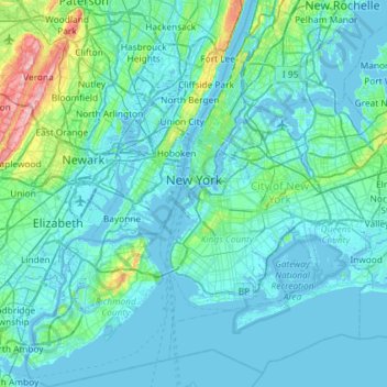
Name: New York topographic map, elevation, terrain.
Location: New York, United States (40.47658 -74.25884 40.91763 -73.70023)
Average elevation: 19 m
Minimum elevation: -6 m
Maximum elevation: 207 m
Make a donation
Other topographic maps
Click on a map to view its topography, its elevation and its terrain.
Central Park
United States > New York > New York County > New York
In June 1856, Fernando Wood appointed a "consulting board" of seven people, headed by author Washington Irving, to inspire public confidence in the proposed development. Wood hired military engineer Egbert Ludovicus Viele as the park's chief engineer, tasking him with a topographical survey of the site. The…
Average elevation: 26 m
Tusten Mountain Lake
United States > New York > Sullivan County > Town of Tusten
Average elevation: 346 m
Make a donation
Central Park
United States > New York > New York County > New York
In June 1856, Fernando Wood appointed a "consulting board" of seven people, headed by author Washington Irving, to inspire public confidence in the proposed development. Wood hired military engineer Egbert Ludovicus Viele as the park's chief engineer, tasking him with a topographical survey of the site. The…
Average elevation: 26 m
Make a donation
Mount Marcy
United States > New York > Essex County > Town of Keene
Mount Marcy is the highest point in the Adirondack Mountains and the U.S. state of New York, with an elevation of 5,343.1 feet (1,628.6 m). It is located in the town of Keene in Essex County. The mountain is in the heart of the High Peaks Wilderness Area in Adirondack Park. Like the surrounding Adirondack…
Average elevation: 1,289 m
Tug Hill
United States > New York > Oswego County
The core Tug Hill region encompasses 150,000 acres (610 km2) of unbroken, generally second-growth, northern hardwood forest, and is drained by a vast network of streams. Important rivers and streams whose headwaters are located within the Tug Hill region include the Mohawk River, Deer River, Salmon River, Mad…
Average elevation: 109 m
Make a donation
Chenango Lake
United States > New York > Chenango County > Town of New Berlin
Average elevation: 513 m
Make a donation
Lake Lincolndale
United States > New York > Westchester County > Town of Somers > Shenorock
Average elevation: 162 m
Make a donation
Make a donation
Make a donation
Make a donation
Make a donation
Beaver Dam Lake
United States > New York > Orange County > Town of New Windsor
Average elevation: 118 m
Make a donation
East Poestenkill
United States > New York > Rensselaer County > Town of Poestenkill
Average elevation: 376 m
Make a donation
Make a donation
Hawthorne
United States > New York > Westchester County > Town of Mount Pleasant
Average elevation: 119 m
Make a donation
Make a donation
Roberto Clemente State Park
United States > New York > Bronx County > New York
Average elevation: 32 m
Upper Lansingburg Reservoir Dam
United States > New York > Rensselaer County > City of Troy
Average elevation: 92 m
Make a donation
Make a donation
Make a donation
Catskills Visitor Center
United States > New York > Ulster County > Town of Shandaken > Beechford
Average elevation: 301 m
Make a donation
Make a donation
Benjamin's Memorial Beach
United States > New York > Suffolk County > Bay Shore
Average elevation: 2 m
Fisherman's Landing
United States > New York > Erie County > Town of Grand Island > Grandyle Village
Average elevation: 179 m
Barberville
United States > New York > Rensselaer County > Town of Poestenkill
Average elevation: 269 m
Chestnut Ridge Park
United States > New York > Erie County > Town of Orchard Park
Average elevation: 314 m
Make a donation
Make a donation
Trumbull Corners
United States > New York > Tompkins County > Town of Newfield
Average elevation: 443 m
Ellicottville
United States > New York > Cattaraugus County > Village of Ellicottville
Average elevation: 573 m
Make a donation
Benjamin's Memorial Beach
United States > New York > Suffolk County > Bay Shore
Average elevation: 2 m
Vails Gate Junction
United States > New York > Orange County > Town of New Windsor > Vails Gate
Average elevation: 92 m
Make a donation
Whitehall Corners
United States > New York > Westchester County > Town of Somers
Average elevation: 97 m
Make a donation
Niagara Escarpment
United States > New York > Niagara County > City of Lockport
Average elevation: 149 m
West Saint Johnsville
United States > New York > Montgomery County > Town of Saint Johnsville
Average elevation: 151 m
Beechmont
United States > New York > Westchester County > City of New Rochelle
Average elevation: 31 m
Make a donation