
Baltimore topographic map
Interactive map
Click on the map to display elevation.
About this map
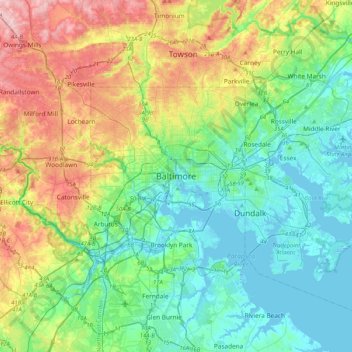
Name: Baltimore topographic map, elevation, terrain.
Location: Baltimore, Maryland, 21203, United States (39.13088 -76.77076 39.45088 -76.45076)
Average elevation: 65 m
Minimum elevation: -5 m
Maximum elevation: 219 m
Baltimore is in north-central Maryland on the Patapsco River close to where it empties into the Chesapeake Bay. The city is also located on the fall line between the Piedmont Plateau and the Atlantic coastal plain, which divides Baltimore into "lower city" and "upper city". The city's elevation ranges from sea level at the harbor to 480 feet (150 m) in the northwest corner near Pimlico.