
Florida topographic map
Interactive map
Click on the map to display elevation.
About this map
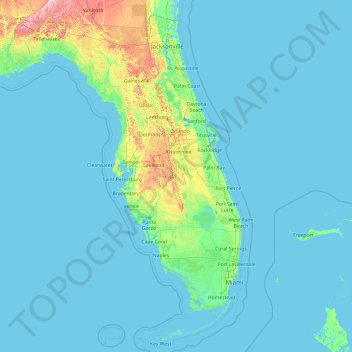
Name: Florida topographic map, elevation, terrain.
Location: Florida, United States (24.39631 -87.63490 31.00076 -79.97431)
Average elevation: 6 m
Minimum elevation: -3 m
Maximum elevation: 111 m
Economic prosperity in the 1920s stimulated tourism to Florida and related development of hotels and resort communities. Combined with its sudden elevation in profile was the Florida land boom of the 1920s, which brought a brief period of intense land development. In 1925, the Seaboard Air Line broke the FEC's southeast Florida monopoly and extended its freight and passenger service to West Palm Beach; two years later it extended passenger service to Miami. Devastating hurricanes in 1926 and 1928, followed by the Great Depression, brought that period to a halt. Florida's economy did not fully recover until the military buildup for World War II.
Other topographic maps
Click on a map to view its topography, its elevation and its terrain.
Las Vegas
United States > Nevada > Clark County
Las Vegas, Clark County, Nevada, United States
Average elevation: 756 m
The Villages
United States > Florida > Sumter County
The Villages, Sumter County, Florida, United States
Average elevation: 25 m
Detroit
United States > Michigan > Wayne County
Detroit, Wayne County, Michigan, United States
Average elevation: 187 m
Big Lake
United States > Texas > Reagan County
Big Lake, Reagan County, Texas, 76932, United States
Average elevation: 820 m
Meridian
United States > Mississippi > Lauderdale County
Meridian, Lauderdale County, Mississippi, United States
Average elevation: 118 m
Westmorland
United States > California > Imperial County
Westmorland, Imperial County, California, United States
Average elevation: -51 m
Paris
United States > Maine > Oxford County
Paris, Oxford County, Maine, 04281, United States
Average elevation: 204 m
Everest
United States > Kansas > Brown County
Everest, Brown County, Kansas, United States
Average elevation: 346 m
Cougar Creek Park
United States > Nevada > Clark County > Las Vegas > Enterprise
Cougar Creek Park, 6635, Enterprise, Las Vegas, Clark County, Nevada, 89139, United States
Average elevation: 771 m
Phoenix
United States > Arizona > Maricopa County
Phoenix, Maricopa County, Arizona, United States
Average elevation: 481 m
Sparks
United States > Nevada > Washoe County
Sparks, Washoe County, Nevada, United States
Average elevation: 1,438 m
Nashville-Davidson
United States > Tennessee > Davidson County
Nashville-Davidson, Davidson County, Middle Tennessee, Tennessee, United States
Average elevation: 184 m
Shelbina
United States > Missouri > Shelby County
Shelbina, Shelby County, Missouri, 63468, United States
Average elevation: 233 m
Louisville
United States > Kentucky > Jefferson County
Louisville, Jefferson County, Kentucky, United States
Average elevation: 188 m
South Bend
United States > Indiana > Saint Joseph County
South Bend, Saint Joseph County, Indiana, United States
Average elevation: 236 m
Lewiston
United States > Idaho > Nez Perce County
Lewiston, Nez Perce County, Idaho, 83501, United States
Average elevation: 334 m
Cupertino
United States > California > Santa Clara County
Cupertino, Santa Clara County, California, 95014, United States
Average elevation: 102 m
Circleville
United States > Ohio > Pickaway County
Circleville, Pickaway County, Ohio, United States
Average elevation: 212 m
El Paso
United States > Texas > El Paso County
El Paso, El Paso County, Texas, United States
Average elevation: 1,237 m
Fort Worth
United States > Texas > Tarrant County
Fort Worth, Tarrant County, Texas, United States
Average elevation: 212 m
Grand Rapids
United States > Michigan > Kent County
Grand Rapids, Kent County, Michigan, United States
Average elevation: 216 m
Flint
United States > Michigan > Genesee County
Flint, Genesee County, Michigan, United States
Average elevation: 236 m
Cairo
United States > Florida > Hillsborough County > Tampa
Cairo, Tampa, Hillsborough County, Florida, 33602, United States
Average elevation: 10 m
Dallas
United States > Texas > Dallas County
Dallas, Dallas County, Texas, United States
Average elevation: 160 m
Atlanta
United States > Georgia > Fulton County
Atlanta, Fulton County, Georgia, United States
Average elevation: 284 m
Memphis
United States > Tennessee > Shelby County
Memphis, Shelby County, West Tennessee, Tennessee, United States
Average elevation: 81 m
Graysville
United States > Alabama > Jefferson County
Graysville, Jefferson County, Alabama, 35073, United States
Average elevation: 138 m
Town of West Monroe
United States > New York > Oswego County
Town of West Monroe, Oswego County, New York, 13167, United States
Average elevation: 138 m
Oceanview
United States > South Carolina > Charleston County
Oceanview, Charleston County, South Carolina, 29412, United States
Average elevation: 2 m
Washburn Falls
United States > Wisconsin > Florence County > Town of Fern
Washburn Falls, Town of Fern, Florence County, Wisconsin, United States
Average elevation: 411 m
Jackson
United States > Mississippi > Hinds County
Jackson, Hinds County, Mississippi, United States
Average elevation: 96 m
Blackfoot
United States > Idaho > Bingham County
Blackfoot, Bingham County, Idaho, 83221, United States
Average elevation: 1,371 m
West Jordan
United States > Utah > Salt Lake County
West Jordan, Salt Lake County, Utah, United States
Average elevation: 1,372 m
Rock Island County
Rock Island County, Illinois, United States
Average elevation: 213 m
Middleburg
United States > Pennsylvania > Snyder County
Middleburg, Snyder County, Pennsylvania, 17842, United States
Average elevation: 173 m
Downingtown
United States > Pennsylvania > Chester County
Downingtown, Chester County, Pennsylvania, 19335, United States
Average elevation: 106 m
Ferry Hill
United States > Massachusetts > Plymouth County > Marshfield
Ferry Hill, Marshfield, Plymouth County, Massachusetts, 02047, United States
Average elevation: 10 m
Craigsville
United States > West Virginia > Nicholas County > Craigsville
Craigsville, Nicholas County, West Virginia, 26205, United States
Average elevation: 692 m
San Dimas
San Dimas, California, 91773, United States
Average elevation: 355 m
Splash Island
United States > Indiana > Hendricks County > Plainfield
Splash Island, Pike Lane, Plainfield, Hendricks County, Indiana, 46168, United States
Average elevation: 232 m
Chanceford Township
United States > Pennsylvania > York County
Chanceford Township, York County, Pennsylvania, 17309, United States
Average elevation: 192 m
Virgin Islands
United States > United States Virgin Islands > Saint Croix District
Virgin Islands, Saint Croix District, United States Virgin Islands, United States
Average elevation: 2 m
Tancred
United States > California > Yolo County
Tancred, Yolo County, California, 95606, United States
Average elevation: 112 m
Miles
United States > Iowa > Jackson County
Miles, Jackson County, Iowa, United States
Average elevation: 248 m