
Lào Cai Province topographic map
Interactive map
Click on the map to display elevation.
About this map
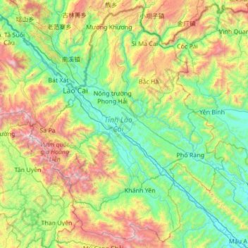
Name: Lào Cai Province topographic map, elevation, terrain.
Location: Lào Cai Province, Vietnam (21.87581 103.52943 22.84492 104.62866)
Average elevation: 865 m
Minimum elevation: 40 m
Maximum elevation: 3,053 m
There are ten major soil groups under 30 categories in the province, under ten land groups. The land groups are: The Alluvial group (1.47% of the land area) along the Red River is good for growing food crops and trees; the Oxisol type which occupies 40% of land area has generally reddish brown soil, below altitude of 900 metres (3,000 ft), is a fertile land suitable for the annual and commercial crops; Team Red Yellow soil humus covers 30% land area in the Sa Pa, Mường Khương, Bắc Hà, Bát Xát districts of the province suitable for medicinal plants, fruit trees and vegetables; humus soil on the mountain occupies 11.42% of the land area mostly in Sa Pa district which has rich canopy of mixed forest; and the Oxisol color altered by rice in 2% of land area are formed into a landscape of terraced fields, as seen in Bắc Hà and Sa Pa districts.
Other topographic maps
Click on a map to view its topography, its elevation and its terrain.
Hoa Long Commune
Vietnam > Bà Rịa - Vũng Tàu Province > Bà Rịa
Hoa Long Commune, Bà Rịa, Bà Rịa - Vũng Tàu Province, Vietnam
Average elevation: 21 m
Nhị Bình
Vietnam > Tiền Giang Province > Châu Thành District > Xã Nhị Bình
Nhị Bình, Xã Nhị Bình, Châu Thành District, Tiền Giang Province, Vietnam
Average elevation: 3 m
Hue City
Vietnam > Thừa Thiên Huế Province
Hue City, Thừa Thiên Huế Province, 54000, Vietnam
Average elevation: 24 m
Mũi Né
Vietnam > Bình Thuận Province > Phan Thiết City
Mũi Né, Phan Thiết City, Bình Thuận Province, Vietnam
Average elevation: 58 m
Tân Lạc District
Tân Lạc District, Hoà Bình province, Vietnam
Average elevation: 416 m
Buon Ma Thuot
Buon Ma Thuot, Đăk Lăk Province, 63107, Vietnam
Average elevation: 442 m
Ban Gioc (Detian) waterfall
Vietnam > Cao Bằng Province > Trùng Khánh District
Ban Gioc (Detian) waterfall, Trùng Khánh District, Cao Bằng Province, Vietnam
Average elevation: 493 m
Xuân Hải
Xuân Hải, Thị xã Sông Cầu, Phu Yen province, Vietnam
Average elevation: 28 m
Phu Nhuan District
Phu Nhuan District, Ho Chi Minh City, Vietnam
Average elevation: 11 m
Can Gio District
Can Gio District, Ho Chi Minh City, Vietnam
Average elevation: 2 m
Ninh Bình
Ninh Bình, Ninh Bình Province, 08000, Vietnam
Average elevation: 5 m
Phú Mỹ Town
Vietnam > Ba Ria-Vung Tau Province > Phú Mỹ Town
Phú Mỹ Town, Ba Ria-Vung Tau Province, Vietnam
Average elevation: 28 m
Di Linh District
Di Linh District, Lâm Đồng Province, Vietnam
Average elevation: 728 m
Can Tho
Vietnam > Can Tho City > Can Tho
Can Tho, Can Tho City, +84 796 943 302, Vietnam
Average elevation: 3 m
Ho Chi Minh City
Vietnam > Ho Chi Minh City > Ho Chi Minh City
Ho Chi Minh City, 70000, Vietnam
Average elevation: 6 m
Nha Trang
Vietnam > Khanh Hoa province > Nha Trang
Nha Trang, Khanh Hoa province, 48058, Vietnam
Average elevation: 113 m
Cần Giờ
Vietnam > Ho Chi Minh City > Đông Hòa > Long Hoà
Cần Giờ, Long Hoà, Can Gio District, Ho Chi Minh City, Vietnam
Average elevation: 1 m
Sa Pa District
Sa Pa District, Lao Cai province, Vietnam
Average elevation: 1,276 m
Ngoc Hien District
Ngoc Hien District, Ca Mau province, Vietnam
Average elevation: 1 m
Tan Long Island
Tan Long Island, My Tho, Mỹ Tho, Tien Giang province, Vietnam
Average elevation: 3 m
Phu Quoc Island
Phu Quoc Island, Phu Quoc, Phu Quoc Island, Vietnam
Average elevation: 17 m
Tam Đường District
Tam Đường District, Lai Chau province, Vietnam
Average elevation: 1,317 m