
Las Vegas topographic map
Interactive map
Click on the map to display elevation.
About this map
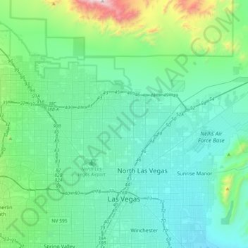
Name: Las Vegas topographic map, elevation, terrain.
Location: Las Vegas, Clark County, Nevada, United States (36.12955 -115.42428 36.38084 -115.06207)
Average elevation: 756 m
Minimum elevation: 505 m
Maximum elevation: 2,100 m
The peaks surrounding Las Vegas reach elevations of over 10,000 feet (3,000 m), and act as barriers to the strong flow of moisture from the surrounding area. The elevation is approximately 2,030 ft (620 m) above sea level. According to the United States Census Bureau, the city has a total area of 135.86 sq mi (351.9 km2), of which 135.81 sq mi (351.7 km2) is land and 0.05 sq mi (0.13 km2) (0.03%) is water.
Other topographic maps
Click on a map to view its topography, its elevation and its terrain.
Paradise
United States > Nevada > Clark County
Paradise, Clark County, Nevada, United States
Average elevation: 662 m
Enterprise
United States > Nevada > Clark County > Sloan
Enterprise, Sloan, Clark County, Nevada, United States
Average elevation: 773 m
Nellis Air Force Base
United States > Nevada > Clark County
Nellis Air Force Base, Nellis, Clark County, Nevada, 89115, United States
Average elevation: 579 m
Six Mile Cove
United States > Nevada > Clark County
Six Mile Cove, Clark County, Nevada, United States
Average elevation: 208 m
Henderson
United States > Nevada > Clark County
Henderson, Clark County, Nevada, United States
Average elevation: 691 m
Two Rocks
United States > Nevada > Clark County
Two Rocks, Clark County, Nevada, United States
Average elevation: 771 m
Boulder City
United States > Nevada > Clark County
Boulder City, Clark County, Nevada, United States
Average elevation: 659 m
North Las Vegas
United States > Nevada > Clark County
North Las Vegas, Clark County, Nevada, United States
Average elevation: 684 m