
Malaybalay topographic map
Interactive map
Click on the map to display elevation.
About this map
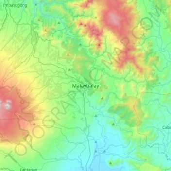
Name: Malaybalay topographic map, elevation, terrain.
Average elevation: 822 m
Minimum elevation: 314 m
Maximum elevation: 2,151 m
The average elevation of the city is 622 metres (2,041 ft) above sea level. About 60% of the city's area has above 30% slope, characterized by steep hills, mountains, and cliff-like stream side. About 25% are level, gently sloping, and undulating. The rest are rolling and hilly.
Other topographic maps
Click on a map to view its topography, its elevation and its terrain.
Incalbog
Philippines > Bukidnon > Malaybalay
Incalbog, Malaybalay, Bukidnon, Northern Mindanao, Philippines
Average elevation: 773 m
Sawaga River
Philippines > Bukidnon > Malaybalay > Casisang
Sawaga River, Casisang, Malaybalay, Bukidnon, Northern Mindanao, 8700, Philippines
Average elevation: 578 m