
Brandon topographic map
Interactive map
Click on the map to display elevation.
About this map
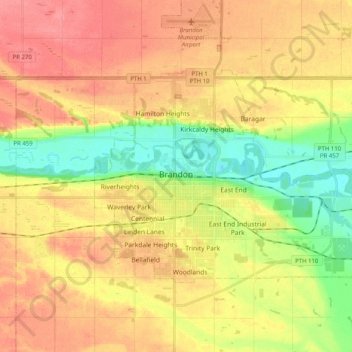
Name: Brandon topographic map, elevation, terrain.
Location: Brandon, Manitoba, Canada (49.81106 -100.00764 49.88953 -99.80605)
Average elevation: 393 m
Minimum elevation: 355 m
Maximum elevation: 424 m
Other topographic maps
Click on a map to view its topography, its elevation and its terrain.
Lake Percy
Lake Percy, 459 Highway, Assiniview Park, Brandon, Manitoba, R7B 2L8, Canada
Average elevation: 372 m