
Vatnajökull topographic map
Interactive map
Click on the map to display elevation.
About this map
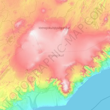
Name: Vatnajökull topographic map, elevation, terrain.
Location: Vatnajökull, Iceland (63.93460 -18.17090 64.83099 -15.21593)
Average elevation: 781 m
Minimum elevation: -2 m
Maximum elevation: 2,016 m
Other topographic maps
Click on a map to view its topography, its elevation and its terrain.
Seydisfjordur
Seydisfjordur, Múlaþing, Eastern Region, 710, Iceland
Average elevation: 443 m
Grindavík
Grindavík, Grindavíkurbær, Southern Peninsula, 240, Iceland
Average elevation: 27 m
Herðubreið
Herðubreið, Skútustaðahreppur, Northeastern Region, Iceland
Average elevation: 1,182 m
Tindfjallajökull
Tindfjallajökull, Hungurfitaskáli, Rangárþing ytra, Southern Region, Iceland
Average elevation: 1,059 m